Neder Holluf geodata
Neder Holluf (South Denmark) is a populated place; located in Denmark in Europe/Copenhagen (GMT+2) time zone. With population of 5,612 people, there are 120 cities with bigger population in this country. Compared to other cities in Denmark, 77.5% of cities are located further ↑North; 54.7% of cities are located further ←West and 56.1% of cities have higher elevation than Neder Holluf. Note1


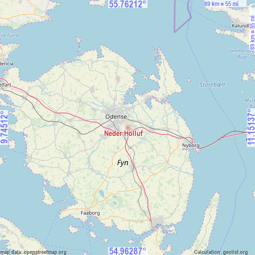
Neder Holluf GPS coordinates[2]
55° 21' 52.236" North, 10° 26' 53.664" East
| Map corner | latitude | longitude |
|---|---|---|
| Upper-left | 55.76212°, | 9.74512° |
| Center: | 55.36451°, | 10.44824° |
| Lower-right: | 54.96287°, | 11.15137° |
| Map W x H: | 88.9×88.9 km | = 55.2×55.2mi |
| max Lat: | 57.72093° ⇑77.5% North |
| Neder Holluf: | 55.36451° |
| min Lat: | ⇓22.5% South 54.57644° |
| min Long | Neder Holluf | max Long |
| 8.12605° | 10.44824° | 15.18662° |
| W 54.7%⇐ | ⇒45.3% E |
Elevation
Elevation of Neder Holluf is 17 m = 56 ft, and this is 10.3 m = 34 ft below average elevation for this country.
| Max E: |
114 m = 374 ft | 56.1% |
| Avg. | 27.3 m = 90 ft | |
| Neder Holluf | 17 m = 56 ft | |
Min E: |
0 m = 0 ft | 43.9% |
See also: Denmark elevation on elevation.city.
Geographical zone
Neder Holluf is located in North temperate zone (between Tropic of Cancer and the Arctic Circle). Distance of this North polar circle is 1245.2 km =773.7 mi to North.| Distance of | km | miles | from Neder Holluf |
|---|---|---|---|
| North Pole | 3851.1 | 2393 | to North |
| Arctic Circle | 1245.2 | 773.7 | to North |
| Tropic Cancer | 3550 | 2205.9 | to South |
| Equator | 6156 | 3825.2 | to South |


Nearby cities:
15 places around Neder Holluf: (largest is in red/bold)
• Bellinge
8.7 km =5.4 mi,  248°
248°
• Bullerup
7.1 km =4.4 mi,  11°
11°
• Højby
3.7 km =2.3 mi,  190°
190°
• Kerteminde
16.2 km =10.1 mi,  54°
54°
• Langeskov
8.7 km =5.4 mi,  95°
95°
• Munkebo
12.1 km =7.5 mi,  33°
33°
• Odense
5.2 km =3.2 mi,  312°
312°
• Otterup
17.1 km =10.6 mi,  349°
349°
• Ringe
14.2 km =8.8 mi,  172°
172°
• Seden
6.9 km =4.3 mi,  357°
357°
• Stige
8.7 km =5.4 mi,  343°
343°
• Tommerup
16.1 km =10 mi, 251°
• Tommerup Stationsby
17.3 km =10.7 mi,  262°
262°
• Ullerslev
12.9 km =8 mi,  91°
91°
• Årslev
6.9 km =4.3 mi, 171°
Sources, notices
• [Note1] Compared only with cities in Denmark existing in our database
• [Src1] Map data: © OpenStreetMap contributors (CC-BY-SA)
• [Src2] Other city data from geonames.org with taken over terms of usage.
• [Src3] Geographical zone / Annual Mean Temperature by Robert A. Rohde @ Wikipedia
