Årslev geodata
Årslev (South Denmark) is a populated place; located in Denmark in Europe/Copenhagen (GMT+2) time zone. With population of 3,228 people, there are 196 cities with bigger population in this country. Compared to other cities in Denmark, 82.2% of cities are located further ↑North; 55.3% of cities are located further ←West and 83% of cities have lower elevation than Årslev. Note1


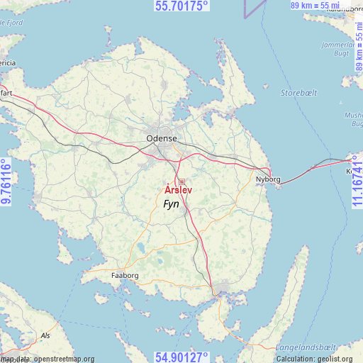
Årslev GPS coordinates[2]
55° 18' 12.708" North, 10° 27' 51.408" East
| Map corner | latitude | longitude |
|---|---|---|
| Upper-left | 55.70175°, | 9.76116° |
| Center: | 55.30353°, | 10.46428° |
| Lower-right: | 54.90127°, | 11.16741° |
| Map W x H: | 89×89 km | = 55.3×55.3mi |
| max Lat: | 57.72093° ⇑82.2% North |
| Årslev: | 55.30353° |
| min Lat: | ⇓17.8% South 54.57644° |
| min Long | Årslev | max Long |
| 8.12605° | 10.46428° | 15.18662° |
| W 55.3%⇐ | ⇒44.7% E |
Elevation
Elevation of Årslev is 49 m = 161 ft, and this is 21.7 m = 71 ft above average elevation for this country.
| Max E: |
114 m = 374 ft | 17% |
| Årslev | 49 m 161 ft | |
| Avg. | 27.3 m = 90 ft | |
Min E: |
0 m = 0 ft | 83% |
See also: Denmark elevation on elevation.city.
Geographical zone
Årslev is located in North temperate zone (between Tropic of Cancer and the Arctic Circle). Distance of this North polar circle is 1252 km =778 mi to North.| Distance of | km | miles | from Årslev |
|---|---|---|---|
| North Pole | 3857.9 | 2397.2 | to North |
| Arctic Circle | 1252 | 778 | to North |
| Tropic Cancer | 3543.3 | 2201.7 | to South |
| Equator | 6149.2 | 3820.9 | to South |


Nearby cities:
15 places around Årslev: (largest is in red/bold)
• Bellinge
9.8 km =6.1 mi,  291°
291°
• Bullerup
13.7 km =8.5 mi,  1°
1°
• Højby
3.6 km =2.2 mi,  331°
331°
• Kerteminde
20.3 km =12.6 mi,  37°
37°
• Langeskov
9.6 km =6 mi,  52°
52°
• Munkebo
17.8 km =11.1 mi,  18°
18°
• Neder Holluf
6.9 km =4.3 mi,  351°
351°
• Nyborg
20.6 km =12.8 mi,  87°
87°
• Odense
11.3 km =7 mi, 334°
• Ringe
7.3 km =4.5 mi,  172°
172°
• Seden
13.7 km =8.5 mi, 354°
• Stige
15.5 km =9.6 mi, 347°
• Tommerup
16.4 km =10.2 mi,  276°
276°
• Tommerup Stationsby
18.8 km =11.7 mi, 284°
• Ullerslev
13.5 km =8.4 mi,  61°
61°
Sources, notices
• [Note1] Compared only with cities in Denmark existing in our database
• [Src1] Map data: © OpenStreetMap contributors (CC-BY-SA)
• [Src2] Other city data from geonames.org with taken over terms of usage.
• [Src3] Geographical zone / Annual Mean Temperature by Robert A. Rohde @ Wikipedia
