Slagelse geodata
Slagelse (Zealand) is a seat of a second-order administrative division; located in Denmark in Europe/Copenhagen (GMT+2) time zone. With population of 31,896 people, there are 25 cities with bigger population in this country. Compared to other cities in Denmark, 75.7% of cities are located further ↑North; 64.3% of cities are located further ←West and 85.1% of cities have lower elevation than Slagelse. Note1


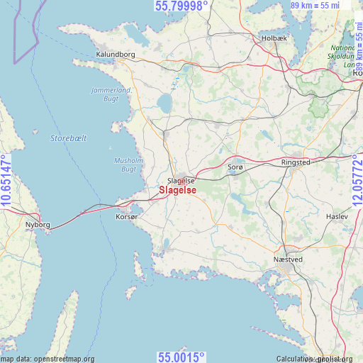
Slagelse GPS coordinates[2]
55° 24' 9.936" North, 11° 21' 16.524" East
| Map corner | latitude | longitude |
|---|---|---|
| Upper-left | 55.79998°, | 10.65147° |
| Center: | 55.40276°, | 11.35459° |
| Lower-right: | 55.0015°, | 12.05772° |
| Map W x H: | 88.8×88.8 km | = 55.2×55.2mi |
| max Lat: | 57.72093° ⇑75.7% North |
| Slagelse: | 55.40276° |
| min Lat: | ⇓24.3% South 54.57644° |
| min Long | Slagelse | max Long |
| 8.12605° | 11.35459° | 15.18662° |
| W 64.3%⇐ | ⇒35.7% E |
Elevation
Elevation of Slagelse is 51 m = 167 ft, and this is 23.7 m = 78 ft above average elevation for this country.
| Max E: |
114 m = 374 ft | 14.9% |
| Slagelse | 51 m 167 ft | |
| Avg. | 27.3 m = 90 ft | |
Min E: |
0 m = 0 ft | 85.1% |
See also: Denmark elevation on elevation.city.
Geographical zone
Slagelse is located in North temperate zone (between Tropic of Cancer and the Arctic Circle). Distance of this North polar circle is 1241 km =771.1 mi to North.| Distance of | km | miles | from Slagelse |
|---|---|---|---|
| North Pole | 3846.9 | 2390.4 | to North |
| Arctic Circle | 1241 | 771.1 | to North |
| Tropic Cancer | 3554.3 | 2208.5 | to South |
| Equator | 6160.2 | 3827.8 | to South |


Nearby cities:
15 places around Slagelse: (largest is in red/bold)
• Dianalund
16.7 km =10.4 mi,  31°
31°
• Fensmark
31.6 km =19.6 mi,  115°
115°
• Forlev
6.8 km =4.2 mi,  242°
242°
• Frederiksberg
13.6 km =8.5 mi,  83°
83°
• Fuglebjerg
16.3 km =10.1 mi,  131°
131°
• Gørlev
17.2 km =10.7 mi,  332°
332°
• Høng
12.3 km =7.6 mi,  340°
340°
• Jyderup
29.3 km =18.2 mi,  8°
8°
• Korsør
15.9 km =9.9 mi, 239°
• Næstved
32.1 km =19.9 mi, 126°
• Ringsted
27.8 km =17.3 mi, 80°
• Skælskør
17.4 km =10.8 mi,  192°
192°
• Sorø
13.1 km =8.1 mi, 75°
• Stenlille
21.2 km =13.2 mi,  44°
44°
• Svebølle
28 km =17.4 mi,  351°
351°
Sources, notices
• [Note1] Compared only with cities in Denmark existing in our database
• [Src1] Map data: © OpenStreetMap contributors (CC-BY-SA)
• [Src2] Other city data from geonames.org with taken over terms of usage.
• [Src3] Geographical zone / Annual Mean Temperature by Robert A. Rohde @ Wikipedia
