Korsør geodata
Korsør (Zealand) is a populated place; located in Denmark in Europe/Copenhagen (GMT+2) time zone. With population of 15,029 people, there are 49 cities with bigger population in this country. Compared to other cities in Denmark, 80.1% of cities are located further ↑North; 62.6% of cities are located further ←West and 98% of cities have higher elevation than Korsør. Note1


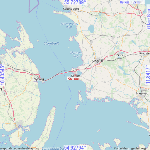
Korsør GPS coordinates[2]
55° 19' 47.748" North, 11° 8' 18.852" East
| Map corner | latitude | longitude |
|---|---|---|
| Upper-left | 55.72789°, | 10.43545° |
| Center: | 55.32993°, | 11.13857° |
| Lower-right: | 54.92794°, | 11.8417° |
| Map W x H: | 88.9×88.9 km | = 55.2×55.2mi |
| max Lat: | 57.72093° ⇑80.1% North |
| Korsør: | 55.32993° |
| min Lat: | ⇓19.9% South 54.57644° |
| min Long | Korsør | max Long |
| 8.12605° | 11.13857° | 15.18662° |
| W 62.6%⇐ | ⇒37.4% E |
Elevation
Elevation of Korsør is 2 m = 7 ft, and this is 25.3 m = 83 ft below average elevation for this country.
| Max E: |
114 m = 374 ft | 98% |
| Avg. | 27.3 m = 90 ft | |
| Korsør | 2 m = 7 ft | |
Min E: |
0 m = 0 ft | 2% |
See also: Denmark elevation on elevation.city.
Geographical zone
Korsør is located in North temperate zone (between Tropic of Cancer and the Arctic Circle). Distance of this North polar circle is 1249.1 km =776.2 mi to North.| Distance of | km | miles | from Korsør |
|---|---|---|---|
| North Pole | 3855 | 2395.4 | to North |
| Arctic Circle | 1249.1 | 776.2 | to North |
| Tropic Cancer | 3546.2 | 2203.5 | to South |
| Equator | 6152.1 | 3822.7 | to South |


Nearby cities:
15 places around Korsør: (largest is in red/bold)
• Dianalund
31.6 km =19.6 mi,  44°
44°
• Forlev
9.1 km =5.7 mi,  57°
57°
• Frederiksberg
28.9 km =18 mi,  70°
70°
• Fuglebjerg
26 km =16.2 mi,  95°
95°
• Gørlev
23.9 km =14.9 mi,  13°
13°
• Høng
21.9 km =13.6 mi,  25°
25°
• Kerteminde
33.1 km =20.6 mi,  293°
293°
• Langeskov
35.2 km =21.9 mi,  274°
274°
• Nyborg
22.2 km =13.8 mi, 265°
• Skælskør
13.2 km =8.2 mi,  131°
131°
• Slagelse
15.9 km =9.9 mi, 59°
• Sorø
28.7 km =17.8 mi, 66°
• Stenlille
36.8 km =22.9 mi,  50°
50°
• Svebølle
37 km =23 mi, 14°
• Ullerslev
31 km =19.3 mi,  276°
276°
Sources, notices
• [Note1] Compared only with cities in Denmark existing in our database
• [Src1] Map data: © OpenStreetMap contributors (CC-BY-SA)
• [Src2] Other city data from geonames.org with taken over terms of usage.
• [Src3] Geographical zone / Annual Mean Temperature by Robert A. Rohde @ Wikipedia
