Bjerringbro geodata
Bjerringbro (Central Jutland) is a populated place; located in Denmark in Europe/Copenhagen (GMT+2) time zone. With population of 7,390 people, there are 98 cities with bigger population in this country. Compared to other cities in Denmark, 81.6% of cities are located further ↓South; 74.9% of cities are located further →East and 67% of cities have higher elevation than Bjerringbro. Note1


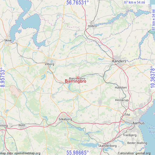
Bjerringbro GPS coordinates[2]
56° 22' 40.692" North, 9° 39' 38.34" East
| Map corner | latitude | longitude |
|---|---|---|
| Upper-left | 56.76531°, | 8.95753° |
| Center: | 56.37797°, | 9.66065° |
| Lower-right: | 55.98665°, | 10.36378° |
| Map W x H: | 86.6×86.6 km | = 53.8×53.8mi |
| max Lat: | 57.72093° ⇑18.4% North |
| Bjerringbro: | 56.37797° |
| min Lat: | ⇓81.6% South 54.57644° |
| min Long | Bjerringbro | max Long |
| 8.12605° | 9.66065° | 15.18662° |
| W 25.1%⇐ | ⇒74.9% E |
Elevation
Elevation of Bjerringbro is 14 m = 46 ft, and this is 13.3 m = 44 ft below average elevation for this country.
| Max E: |
114 m = 374 ft | 67% |
| Avg. | 27.3 m = 90 ft | |
| Bjerringbro | 14 m = 46 ft | |
Min E: |
0 m = 0 ft | 33% |
See also: Denmark elevation on elevation.city.
Geographical zone
Bjerringbro is located in North temperate zone (between Tropic of Cancer and the Arctic Circle). Distance of this North polar circle is 1132.5 km =703.7 mi to North.| Distance of | km | miles | from Bjerringbro |
|---|---|---|---|
| North Pole | 3738.4 | 2322.9 | to North |
| Arctic Circle | 1132.5 | 703.7 | to North |
| Tropic Cancer | 3662.7 | 2275.9 | to South |
| Equator | 6268.6 | 3895.1 | to South |


Nearby cities:
15 places around Bjerringbro: (largest is in red/bold)
• Galten
29 km =18 mi,  146°
146°
• Hadsten
24.6 km =15.3 mi,  103°
103°
• Hammel
18.3 km =11.4 mi,  136°
136°
• Hinnerup
27.8 km =17.3 mi,  116°
116°
• Kjellerup
17.3 km =10.7 mi,  233°
233°
• Langå
14.5 km =9 mi,  84°
84°
• Randers
24.9 km =15.5 mi,  68°
68°
• Sabro
29.4 km =18.3 mi,  128°
128°
• Silkeborg
24.2 km =15 mi,  197°
197°
• Skovby
30.2 km =18.8 mi, 144°
• Spentrup
29.2 km =18.1 mi,  52°
52°
• Svejbæk
27.3 km =17 mi,  183°
183°
• Ulstrup
8.3 km =5.2 mi, 80°
• Viborg
18 km =11.2 mi,  297°
297°
• Virklund
28.1 km =17.5 mi,  193°
193°
Sources, notices
• [Note1] Compared only with cities in Denmark existing in our database
• [Src1] Map data: © OpenStreetMap contributors (CC-BY-SA)
• [Src2] Other city data from geonames.org with taken over terms of usage.
• [Src3] Geographical zone / Annual Mean Temperature by Robert A. Rohde @ Wikipedia
