Ulstrup geodata
Ulstrup (Central Jutland) is a populated place; located in Denmark in Europe/Copenhagen (GMT+2) time zone. With population of 1,963 people, there are 312 cities with bigger population in this country. Compared to other cities in Denmark, 82.2% of cities are located further ↓South; 69.9% of cities are located further →East and 71.9% of cities have higher elevation than Ulstrup. Note1


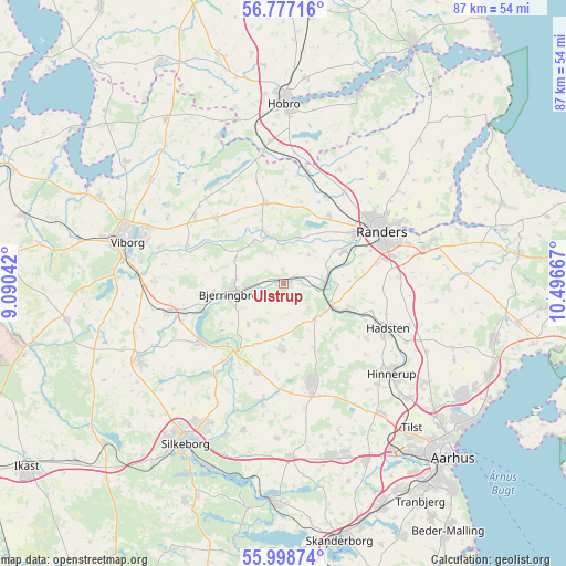
Ulstrup GPS coordinates[2]
56° 23' 23.784" North, 9° 47' 36.744" East
| Map corner | latitude | longitude |
|---|---|---|
| Upper-left | 56.77716°, | 9.09042° |
| Center: | 56.38994°, | 9.79354° |
| Lower-right: | 55.99874°, | 10.49667° |
| Map W x H: | 86.6×86.5 km | = 53.8×53.7mi |
| max Lat: | 57.72093° ⇑17.8% North |
| Ulstrup: | 56.38994° |
| min Lat: | ⇓82.2% South 54.57644° |
| min Long | Ulstrup | max Long |
| 8.12605° | 9.79354° | 15.18662° |
| W 30.1%⇐ | ⇒69.9% E |
Elevation
Elevation of Ulstrup is 12 m = 39 ft, and this is 15.3 m = 50 ft below average elevation for this country.
| Max E: |
114 m = 374 ft | 71.9% |
| Avg. | 27.3 m = 90 ft | |
| Ulstrup | 12 m = 39 ft | |
Min E: |
0 m = 0 ft | 28.1% |
See also: Denmark elevation on elevation.city.
Geographical zone
Ulstrup is located in North temperate zone (between Tropic of Cancer and the Arctic Circle). Distance of this North polar circle is 1131.2 km =702.9 mi to North.| Distance of | km | miles | from Ulstrup |
|---|---|---|---|
| North Pole | 3737.1 | 2322.1 | to North |
| Arctic Circle | 1131.2 | 702.9 | to North |
| Tropic Cancer | 3664.1 | 2276.8 | to South |
| Equator | 6270 | 3896 | to South |


Nearby cities:
15 places around Ulstrup: (largest is in red/bold)
• Assentoft
22.8 km =14.2 mi,  75°
75°
• Bjerringbro
8.3 km =5.2 mi,  260°
260°
• Galten
26.8 km =16.7 mi,  163°
163°
• Hadsten
17.2 km =10.7 mi,  113°
113°
• Hammel
15.3 km =9.5 mi, 163°
• Hinnerup
21.6 km =13.4 mi,  129°
129°
• Kjellerup
24.9 km =15.5 mi,  242°
242°
• Langå
6.2 km =3.9 mi,  89°
89°
• Randers
16.9 km =10.5 mi,  62°
62°
• Sabro
24.6 km =15.3 mi,  142°
142°
• Skovby
27.6 km =17.1 mi, 160°
• Spentrup
22.2 km =13.8 mi,  42°
42°
• Søften
24.7 km =15.3 mi, 133°
• Trige
26.7 km =16.6 mi,  124°
124°
• Viborg
25.1 km =15.6 mi,  286°
286°
Sources, notices
• [Note1] Compared only with cities in Denmark existing in our database
• [Src1] Map data: © OpenStreetMap contributors (CC-BY-SA)
• [Src2] Other city data from geonames.org with taken over terms of usage.
• [Src3] Geographical zone / Annual Mean Temperature by Robert A. Rohde @ Wikipedia
