Kerteminde geodata
Kerteminde (South Denmark) is a seat of a second-order administrative division; located in Denmark in Europe/Copenhagen (GMT+2) time zone. With population of 5,748 people, there are 118 cities with bigger population in this country. Compared to other cities in Denmark, 72.5% of cities are located further ↑North; 59.9% of cities are located further ←West and 89.8% of cities have higher elevation than Kerteminde. Note1


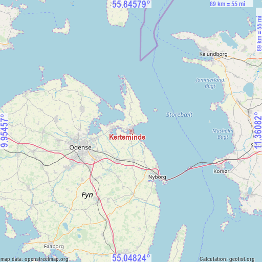
Kerteminde GPS coordinates[2]
55° 26' 56.508" North, 10° 39' 27.684" East
| Map corner | latitude | longitude |
|---|---|---|
| Upper-left | 55.84579°, | 9.95457° |
| Center: | 55.44903°, | 10.65769° |
| Lower-right: | 55.04824°, | 11.36082° |
| Map W x H: | 88.7×88.7 km | = 55.1×55.1mi |
| max Lat: | 57.72093° ⇑72.5% North |
| Kerteminde: | 55.44903° |
| min Lat: | ⇓27.5% South 54.57644° |
| min Long | Kerteminde | max Long |
| 8.12605° | 10.65769° | 15.18662° |
| W 59.9%⇐ | ⇒40.1% E |
Elevation
Elevation of Kerteminde is 5 m = 16 ft, and this is 22.3 m = 73 ft below average elevation for this country.
| Max E: |
114 m = 374 ft | 89.8% |
| Avg. | 27.3 m = 90 ft | |
| Kerteminde | 5 m = 16 ft | |
Min E: |
0 m = 0 ft | 10.2% |
See also: Denmark elevation on elevation.city.
Geographical zone
Kerteminde is located in North temperate zone (between Tropic of Cancer and the Arctic Circle). Distance of this North polar circle is 1235.8 km =767.9 mi to North.| Distance of | km | miles | from Kerteminde |
|---|---|---|---|
| North Pole | 3841.7 | 2387.1 | to North |
| Arctic Circle | 1235.8 | 767.9 | to North |
| Tropic Cancer | 3559.4 | 2211.7 | to South |
| Equator | 6165.4 | 3831 | to South |


Nearby cities:
15 places around Kerteminde: (largest is in red/bold)
• Bellinge
24.8 km =15.4 mi,  239°
239°
• Bullerup
12 km =7.5 mi,  258°
258°
• Højby
19.1 km =11.9 mi,  226°
226°
• Langeskov
11.3 km =7 mi,  204°
204°
• Munkebo
6.6 km =4.1 mi,  276°
276°
• Neder Holluf
16.2 km =10.1 mi, 234°
• Nyborg
17.3 km =10.7 mi,  151°
151°
• Odense
18 km =11.2 mi,  250°
250°
• Otterup
18 km =11.2 mi,  294°
294°
• Ringe
26 km =16.2 mi,  205°
205°
• Seden
13.8 km =8.6 mi, 259°
• Stige
15.7 km =9.8 mi,  266°
266°
• Søndersø
25.7 km =16 mi, 279°
• Ullerslev
9.7 km =6 mi,  182°
182°
• Årslev
20.3 km =12.6 mi,  217°
217°
Sources, notices
• [Note1] Compared only with cities in Denmark existing in our database
• [Src1] Map data: © OpenStreetMap contributors (CC-BY-SA)
• [Src2] Other city data from geonames.org with taken over terms of usage.
• [Src3] Geographical zone / Annual Mean Temperature by Robert A. Rohde @ Wikipedia
