Grindsted geodata
Grindsted (South Denmark) is a seat of a second-order administrative division; located in Denmark in Europe/Copenhagen (GMT+2) time zone. With population of 9,414 people, there are 79 cities with bigger population in this country. Compared to other cities in Denmark, 52.9% of cities are located further ↓South; 90.9% of cities are located further →East and 76% of cities have lower elevation than Grindsted. Note1


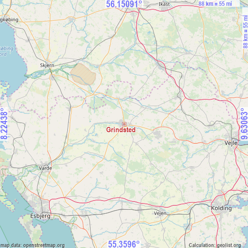
Grindsted GPS coordinates[2]
55° 45' 26.136" North, 8° 55' 39" East
| Map corner | latitude | longitude |
|---|---|---|
| Upper-left | 56.15091°, | 8.22438° |
| Center: | 55.75726°, | 8.9275° |
| Lower-right: | 55.3596°, | 9.63063° |
| Map W x H: | 88×88 km | = 54.7×54.7mi |
| max Lat: | 57.72093° ⇑47.1% North |
| Grindsted: | 55.75726° |
| min Lat: | ⇓52.9% South 54.57644° |
| min Long | Grindsted | max Long |
| 8.12605° | 8.9275° | 15.18662° |
| W 9.1%⇐ | ⇒90.9% E |
Elevation
Elevation of Grindsted is 42 m = 138 ft, and this is 14.7 m = 48 ft above average elevation for this country.
| Max E: |
114 m = 374 ft | 24% |
| Grindsted | 42 m 138 ft | |
| Avg. | 27.3 m = 90 ft | |
Min E: |
0 m = 0 ft | 76% |
See also: Denmark elevation on elevation.city.
Geographical zone
Grindsted is located in North temperate zone (between Tropic of Cancer and the Arctic Circle). Distance of this North polar circle is 1201.5 km =746.6 mi to North.| Distance of | km | miles | from Grindsted |
|---|---|---|---|
| North Pole | 3807.4 | 2365.8 | to North |
| Arctic Circle | 1201.5 | 746.6 | to North |
| Tropic Cancer | 3593.7 | 2233 | to South |
| Equator | 6199.6 | 3852.3 | to South |


Nearby cities:
15 places around Grindsted: (largest is in red/bold)
• Billund
11.6 km =7.2 mi,  103°
103°
• Bramming
35 km =21.7 mi,  204°
204°
• Brande
24.2 km =15 mi,  31°
31°
• Brørup
31.1 km =19.3 mi,  169°
169°
• Egtved
28.5 km =17.7 mi,  123°
123°
• Give
21.7 km =13.5 mi,  63°
63°
• Holsted
27.4 km =17 mi,  181°
181°
• Jelling
31.2 km =19.4 mi,  90°
90°
• Kibæk
30.8 km =19.1 mi,  351°
351°
• Skjern
34.2 km =21.3 mi,  308°
308°
• Tarm
30 km =18.6 mi,  304°
304°
• Tørring
36.2 km =22.5 mi,  73°
73°
• Varde
31.8 km =19.8 mi,  241°
241°
• Vejen
33.4 km =20.8 mi,  156°
156°
• Ølgod
19.5 km =12.1 mi,  286°
286°
Sources, notices
• [Note1] Compared only with cities in Denmark existing in our database
• [Src1] Map data: © OpenStreetMap contributors (CC-BY-SA)
• [Src2] Other city data from geonames.org with taken over terms of usage.
• [Src3] Geographical zone / Annual Mean Temperature by Robert A. Rohde @ Wikipedia
