Billund geodata
Billund (South Denmark) is a populated place; located in Denmark in Europe/Copenhagen (GMT+2) time zone. With population of 6,160 people, there are 113 cities with bigger population in this country. Compared to other cities in Denmark, 50.6% of cities are located further ↑North; 87.4% of cities are located further →East and 89.8% of cities have lower elevation than Billund. Note1


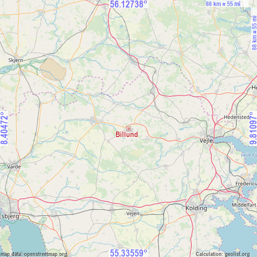
Billund GPS coordinates[2]
55° 44' 0.564" North, 9° 6' 28.26" East
| Map corner | latitude | longitude |
|---|---|---|
| Upper-left | 56.12738°, | 8.40472° |
| Center: | 55.73349°, | 9.10785° |
| Lower-right: | 55.33559°, | 9.81097° |
| Map W x H: | 88×88 km | = 54.7×54.7mi |
| max Lat: | 57.72093° ⇑50.6% North |
| Billund: | 55.73349° |
| min Lat: | ⇓49.4% South 54.57644° |
| min Long | Billund | max Long |
| 8.12605° | 9.10785° | 15.18662° |
| W 12.6%⇐ | ⇒87.4% E |
Elevation
Elevation of Billund is 58 m = 190 ft, and this is 30.7 m = 101 ft above average elevation for this country.
| Max E: |
114 m = 374 ft | 10.2% |
| Billund | 58 m 190 ft | |
| Avg. | 27.3 m = 90 ft | |
Min E: |
0 m = 0 ft | 89.8% |
See also: Denmark elevation on elevation.city.
Geographical zone
Billund is located in North temperate zone (between Tropic of Cancer and the Arctic Circle). Distance of this North polar circle is 1204.2 km =748.3 mi to North.| Distance of | km | miles | from Billund |
|---|---|---|---|
| North Pole | 3810.1 | 2367.5 | to North |
| Arctic Circle | 1204.2 | 748.3 | to North |
| Tropic Cancer | 3591.1 | 2231.4 | to South |
| Equator | 6197 | 3850.6 | to South |


Nearby cities:
15 places around Billund: (largest is in red/bold)
• Brande
23.3 km =14.5 mi,  3°
3°
• Brørup
28.5 km =17.7 mi,  191°
191°
• Børkop
35.4 km =22 mi,  106°
106°
• Egtved
18.1 km =11.2 mi,  136°
136°
• Give
14.8 km =9.2 mi,  33°
33°
• Grindsted
11.6 km =7.2 mi,  283°
283°
• Holsted
27.5 km =17.1 mi,  205°
205°
• Jelling
20.1 km =12.5 mi,  82°
82°
• Kolding
35.4 km =22 mi, 139°
• Lunderskov
30.3 km =18.8 mi,  156°
156°
• Tørring
26.8 km =16.7 mi,  61°
61°
• Vamdrup
35.8 km =22.2 mi, 161°
• Vejen
28.1 km =17.5 mi,  176°
176°
• Vejle
26.9 km =16.7 mi,  95°
95°
• Ølgod
31.1 km =19.3 mi,  285°
285°
Sources, notices
• [Note1] Compared only with cities in Denmark existing in our database
• [Src1] Map data: © OpenStreetMap contributors (CC-BY-SA)
• [Src2] Other city data from geonames.org with taken over terms of usage.
• [Src3] Geographical zone / Annual Mean Temperature by Robert A. Rohde @ Wikipedia
