Bramming geodata
Bramming (South Denmark) is a populated place; located in Denmark in Europe/Copenhagen (GMT+2) time zone. With population of 6,726 people, there are 108 cities with bigger population in this country. Compared to other cities in Denmark, 70.2% of cities are located further ↑North; 94.2% of cities are located further →East and 63.2% of cities have higher elevation than Bramming. Note1


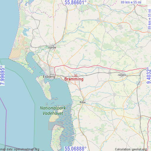
Bramming GPS coordinates[2]
55° 28' 10.056" North, 8° 42' 0.252" East
| Map corner | latitude | longitude |
|---|---|---|
| Upper-left | 55.86601°, | 7.99695° |
| Center: | 55.46946°, | 8.70007° |
| Lower-right: | 55.06888°, | 9.4032° |
| Map W x H: | 88.6×88.6 km | = 55.1×55.1mi |
| max Lat: | 57.72093° ⇑70.2% North |
| Bramming: | 55.46946° |
| min Lat: | ⇓29.8% South 54.57644° |
| min Long | Bramming | max Long |
| 8.12605° | 8.70007° | 15.18662° |
| W 5.8%⇐ | ⇒94.2% E |
Elevation
Elevation of Bramming is 15 m = 49 ft, and this is 12.3 m = 40 ft below average elevation for this country.
| Max E: |
114 m = 374 ft | 63.2% |
| Avg. | 27.3 m = 90 ft | |
| Bramming | 15 m = 49 ft | |
Min E: |
0 m = 0 ft | 36.8% |
See also: Denmark elevation on elevation.city.
Geographical zone
Bramming is located in North temperate zone (between Tropic of Cancer and the Arctic Circle). Distance of this North polar circle is 1233.5 km =766.5 mi to North.| Distance of | km | miles | from Bramming |
|---|---|---|---|
| North Pole | 3839.4 | 2385.7 | to North |
| Arctic Circle | 1233.5 | 766.5 | to North |
| Tropic Cancer | 3561.7 | 2213.1 | to South |
| Equator | 6167.6 | 3832.4 | to South |


Nearby cities:
15 places around Bramming: (largest is in red/bold)
• Brørup
20.1 km =12.5 mi,  86°
86°
• Esbjerg
15.6 km =9.7 mi,  270°
270°
• Gram
29.8 km =18.5 mi,  132°
132°
• Grindsted
35 km =21.7 mi,  24°
24°
• Holsted
14.5 km =9 mi,  71°
71°
• Lunderskov
37.8 km =23.5 mi, 87°
• Nordby
19.2 km =11.9 mi,  262°
262°
• Oksbøl
31.3 km =19.4 mi,  303°
303°
• Ribe
16.1 km =10 mi,  164°
164°
• Rødding
25.7 km =16 mi,  116°
116°
• Skaerbaek
35 km =21.7 mi,  172°
172°
• Tjæreborg
7.6 km =4.7 mi, 265°
• Vamdrup
37.1 km =23.1 mi,  97°
97°
• Varde
21.8 km =13.5 mi,  320°
320°
• Vejen
27.6 km =17.1 mi, 87°
Sources, notices
• [Note1] Compared only with cities in Denmark existing in our database
• [Src1] Map data: © OpenStreetMap contributors (CC-BY-SA)
• [Src2] Other city data from geonames.org with taken over terms of usage.
• [Src3] Geographical zone / Annual Mean Temperature by Robert A. Rohde @ Wikipedia
