Vejen geodata
Vejen (South Denmark) is a seat of a second-order administrative division; located in Denmark in Europe/Copenhagen (GMT+2) time zone. With population of 8,525 people, there are 87 cities with bigger population in this country. Compared to other cities in Denmark, 69.6% of cities are located further ↑North; 86.8% of cities are located further →East and 74.6% of cities have lower elevation than Vejen. Note1


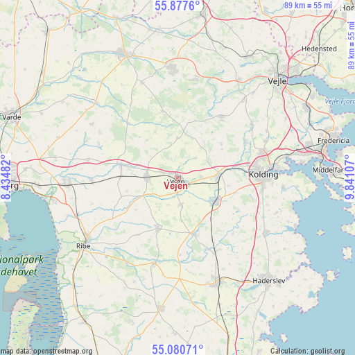
Vejen GPS coordinates[2]
55° 28' 52.212" North, 9° 8' 16.62" East
| Map corner | latitude | longitude |
|---|---|---|
| Upper-left | 55.8776°, | 8.43482° |
| Center: | 55.48117°, | 9.13795° |
| Lower-right: | 55.08071°, | 9.84107° |
| Map W x H: | 88.6×88.6 km | = 55.1×55.1mi |
| max Lat: | 57.72093° ⇑69.6% North |
| Vejen: | 55.48117° |
| min Lat: | ⇓30.4% South 54.57644° |
| min Long | Vejen | max Long |
| 8.12605° | 9.13795° | 15.18662° |
| W 13.2%⇐ | ⇒86.8% E |
Elevation
Elevation of Vejen is 41 m = 135 ft, and this is 13.7 m = 45 ft above average elevation for this country.
| Max E: |
114 m = 374 ft | 25.4% |
| Vejen | 41 m 135 ft | |
| Avg. | 27.3 m = 90 ft | |
Min E: |
0 m = 0 ft | 74.6% |
See also: Denmark elevation on elevation.city.
Geographical zone
Vejen is located in North temperate zone (between Tropic of Cancer and the Arctic Circle). Distance of this North polar circle is 1232.2 km =765.7 mi to North.| Distance of | km | miles | from Vejen |
|---|---|---|---|
| North Pole | 3838.1 | 2384.9 | to North |
| Arctic Circle | 1232.2 | 765.7 | to North |
| Tropic Cancer | 3563 | 2213.9 | to South |
| Equator | 6168.9 | 3833.2 | to South |


Nearby cities:
15 places around Vejen: (largest is in red/bold)
• Billund
28.1 km =17.5 mi,  356°
356°
• Bramming
27.6 km =17.1 mi,  267°
267°
• Brørup
7.6 km =4.7 mi, 270°
• Christiansfeld
25.9 km =16.1 mi,  121°
121°
• Egtved
18.4 km =11.4 mi,  35°
35°
• Gram
22 km =13.7 mi,  194°
194°
• Holsted
14.2 km =8.8 mi,  283°
283°
• Kolding
21.1 km =13.1 mi,  87°
87°
• Lunderskov
10.2 km =6.3 mi, 88°
• Ribe
28.7 km =17.8 mi,  234°
234°
• Rødding
13.7 km =8.5 mi,  200°
200°
• Sønder Bjert
27.3 km =17 mi,  96°
96°
• Taulov
30.9 km =19.2 mi,  76°
76°
• Vamdrup
11 km =6.8 mi, 122°
• Vojens
28.2 km =17.5 mi,  157°
157°
Sources, notices
• [Note1] Compared only with cities in Denmark existing in our database
• [Src1] Map data: © OpenStreetMap contributors (CC-BY-SA)
• [Src2] Other city data from geonames.org with taken over terms of usage.
• [Src3] Geographical zone / Annual Mean Temperature by Robert A. Rohde @ Wikipedia
