Ølgod geodata
Ølgod (South Denmark) is a populated place; located in Denmark in Europe/Copenhagen (GMT+2) time zone. With population of 3,891 people, there are 161 cities with bigger population in this country. Compared to other cities in Denmark, 55% of cities are located further ↓South; 94.7% of cities are located further →East and 72.5% of cities have lower elevation than Ølgod. Note1


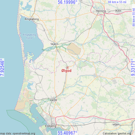
Ølgod GPS coordinates[2]
55° 48' 24.552" North, 8° 37' 42.924" East
| Map corner | latitude | longitude |
|---|---|---|
| Upper-left | 56.19996°, | 7.92546° |
| Center: | 55.80682°, | 8.62859° |
| Lower-right: | 55.40967°, | 9.33171° |
| Map W x H: | 87.9×87.9 km | = 54.6×54.6mi |
| max Lat: | 57.72093° ⇑45% North |
| Ølgod: | 55.80682° |
| min Lat: | ⇓55% South 54.57644° |
| min Long | Ølgod | max Long |
| 8.12605° | 8.62859° | 15.18662° |
| W 5.3%⇐ | ⇒94.7% E |
Elevation
Elevation of Ølgod is 39 m = 128 ft, and this is 11.7 m = 38 ft above average elevation for this country.
| Max E: |
114 m = 374 ft | 27.5% |
| Ølgod | 39 m 128 ft | |
| Avg. | 27.3 m = 90 ft | |
Min E: |
0 m = 0 ft | 72.5% |
See also: Denmark elevation on elevation.city.
Geographical zone
Ølgod is located in North temperate zone (between Tropic of Cancer and the Arctic Circle). Distance of this North polar circle is 1196 km =743.2 mi to North.| Distance of | km | miles | from Ølgod |
|---|---|---|---|
| North Pole | 3801.9 | 2362.4 | to North |
| Arctic Circle | 1196 | 743.2 | to North |
| Tropic Cancer | 3599.2 | 2236.4 | to South |
| Equator | 6205.1 | 3855.7 | to South |


Nearby cities:
15 places around Ølgod: (largest is in red/bold)
• Billund
31.1 km =19.3 mi,  105°
105°
• Bramming
37.8 km =23.5 mi,  173°
173°
• Brande
34.6 km =21.5 mi,  64°
64°
• Esbjerg
39 km =24.2 mi,  196°
196°
• Give
38.3 km =23.8 mi,  83°
83°
• Grindsted
19.5 km =12.1 mi, 106°
• Holsted
37.6 km =23.4 mi,  151°
151°
• Hvide Sande
37.9 km =23.5 mi,  304°
304°
• Kibæk
28.8 km =17.9 mi,  29°
29°
• Oksbøl
29.3 km =18.2 mi,  226°
226°
• Skjern
17.8 km =11.1 mi,  333°
333°
• Tarm
12.9 km =8 mi, 331°
• Tjæreborg
38.2 km =23.7 mi,  184°
184°
• Varde
22.6 km =14 mi, 204°
• Videbæk
31.2 km =19.4 mi,  359°
359°
Sources, notices
• [Note1] Compared only with cities in Denmark existing in our database
• [Src1] Map data: © OpenStreetMap contributors (CC-BY-SA)
• [Src2] Other city data from geonames.org with taken over terms of usage.
• [Src3] Geographical zone / Annual Mean Temperature by Robert A. Rohde @ Wikipedia
