Varde geodata
Varde (South Denmark) is a seat of a second-order administrative division; located in Denmark in Europe/Copenhagen (GMT+2) time zone. With population of 12,735 people, there are 61 cities with bigger population in this country. Compared to other cities in Denmark, 59.9% of cities are located further ↑North; 97.1% of cities are located further →East and 74.3% of cities have higher elevation than Varde. Note1


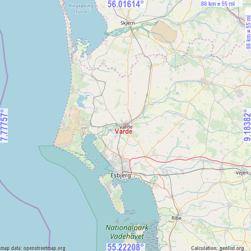
Varde GPS coordinates[2]
55° 37' 16.032" North, 8° 28' 50.484" East
| Map corner | latitude | longitude |
|---|---|---|
| Upper-left | 56.01614°, | 7.77757° |
| Center: | 55.62112°, | 8.48069° |
| Lower-right: | 55.22208°, | 9.18382° |
| Map W x H: | 88.3×88.3 km | = 54.9×54.9mi |
| max Lat: | 57.72093° ⇑59.9% North |
| Varde: | 55.62112° |
| min Lat: | ⇓40.1% South 54.57644° |
| min Long | Varde | max Long |
| 8.12605° | 8.48069° | 15.18662° |
| W 2.9%⇐ | ⇒97.1% E |
Elevation
Elevation of Varde is 11 m = 36 ft, and this is 16.3 m = 53 ft below average elevation for this country.
| Max E: |
114 m = 374 ft | 74.3% |
| Avg. | 27.3 m = 90 ft | |
| Varde | 11 m = 36 ft | |
Min E: |
0 m = 0 ft | 25.7% |
See also: Denmark elevation on elevation.city.
Geographical zone
Varde is located in North temperate zone (between Tropic of Cancer and the Arctic Circle). Distance of this North polar circle is 1216.7 km =756 mi to North.| Distance of | km | miles | from Varde |
|---|---|---|---|
| North Pole | 3822.6 | 2375.3 | to North |
| Arctic Circle | 1216.7 | 756 | to North |
| Tropic Cancer | 3578.6 | 2223.6 | to South |
| Equator | 6184.5 | 3842.9 | to South |


Nearby cities:
15 places around Varde: (largest is in red/bold)
• Billund
41.3 km =25.7 mi,  72°
72°
• Bramming
21.8 km =13.5 mi,  140°
140°
• Brørup
37.1 km =23.1 mi,  114°
114°
• Esbjerg
16.9 km =10.5 mi,  186°
186°
• Grindsted
31.8 km =19.8 mi,  61°
61°
• Holsted
30.1 km =18.7 mi, 113°
• Nordby
20.2 km =12.6 mi, 194°
• Oksbøl
12.1 km =7.5 mi,  272°
272°
• Ribe
37.1 km =23.1 mi,  150°
150°
• Rødding
46.4 km =28.8 mi,  127°
127°
• Skjern
36.6 km =22.7 mi,  1°
1°
• Tarm
32.1 km =19.9 mi,  5°
5°
• Tjæreborg
18.5 km =11.5 mi,  160°
160°
• Vejen
44.2 km =27.5 mi, 110°
• Ølgod
22.6 km =14 mi,  24°
24°
Sources, notices
• [Note1] Compared only with cities in Denmark existing in our database
• [Src1] Map data: © OpenStreetMap contributors (CC-BY-SA)
• [Src2] Other city data from geonames.org with taken over terms of usage.
• [Src3] Geographical zone / Annual Mean Temperature by Robert A. Rohde @ Wikipedia
