Augustenborg geodata
Augustenborg (South Denmark) is a populated place; located in Denmark in Europe/Copenhagen (GMT+2) time zone. With population of 3,132 people, there are 200 cities with bigger population in this country. Compared to other cities in Denmark, 93.3% of cities are located further ↑North; 67% of cities are located further →East and 83.3% of cities have higher elevation than Augustenborg. Note1


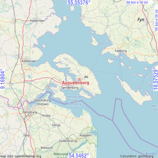
Augustenborg GPS coordinates[2]
54° 57' 7.236" North, 9° 52' 19.776" East
| Map corner | latitude | longitude |
|---|---|---|
| Upper-left | 55.35376°, | 9.16904° |
| Center: | 54.95201°, | 9.87216° |
| Lower-right: | 54.5462°, | 10.57529° |
| Map W x H: | 89.8×89.8 km | = 55.8×55.8mi |
| max Lat: | 57.72093° ⇑93.3% North |
| Augustenborg: | 54.95201° |
| min Lat: | ⇓6.7% South 54.57644° |
| min Long | Augustenborg | max Long |
| 8.12605° | 9.87216° | 15.18662° |
| W 33%⇐ | ⇒67% E |
Elevation
Elevation of Augustenborg is 8 m = 26 ft, and this is 19.3 m = 63 ft below average elevation for this country.
| Max E: |
114 m = 374 ft | 83.3% |
| Avg. | 27.3 m = 90 ft | |
| Augustenborg | 8 m = 26 ft | |
Min E: |
0 m = 0 ft | 16.7% |
See also: Denmark elevation on elevation.city.
Geographical zone
Augustenborg is located in North temperate zone (between Tropic of Cancer and the Arctic Circle). Distance of this North polar circle is 1291.1 km =802.3 mi to North.| Distance of | km | miles | from Augustenborg |
|---|---|---|---|
| North Pole | 3897 | 2421.5 | to North |
| Arctic Circle | 1291.1 | 802.3 | to North |
| Tropic Cancer | 3504.2 | 2177.4 | to South |
| Equator | 6110.1 | 3796.6 | to South |


Nearby cities:
15 places around Augustenborg: (largest is in red/bold)
• Aabenraa
30.8 km =19.1 mi,  289°
289°
• Assens
35.4 km =22 mi,  2°
2°
• Broager
14.4 km =8.9 mi,  241°
241°
• Dybbøl
9.8 km =6.1 mi, 242°
• Faaborg
28.5 km =17.7 mi,  56°
56°
• Gråsten
18.1 km =11.2 mi,  258°
258°
• Guderup
4.2 km =2.6 mi,  359°
359°
• Hårby
34.1 km =21.2 mi,  27°
27°
• Høruphav
5 km =3.1 mi,  159°
159°
• Kruså
32.1 km =19.9 mi,  249°
249°
• Løjt Kirkeby
30.4 km =18.9 mi,  300°
300°
• Nordborg
14.4 km =8.9 mi,  324°
324°
• Padborg
35.5 km =22.1 mi, 246°
• Sønderborg
7.1 km =4.4 mi,  227°
227°
• Ærøskøbing
35.2 km =21.9 mi,  101°
101°
Sources, notices
• [Note1] Compared only with cities in Denmark existing in our database
• [Src1] Map data: © OpenStreetMap contributors (CC-BY-SA)
• [Src2] Other city data from geonames.org with taken over terms of usage.
• [Src3] Geographical zone / Annual Mean Temperature by Robert A. Rohde @ Wikipedia
