Guderup geodata
Guderup (South Denmark) is a populated place; located in Denmark in Europe/Copenhagen (GMT+2) time zone. With population of 2,424 people, there are 258 cities with bigger population in this country. Compared to other cities in Denmark, 92.7% of cities are located further ↑North; 67.3% of cities are located further →East and 59.4% of cities have lower elevation than Guderup. Note1


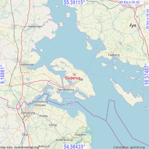
Guderup GPS coordinates[2]
54° 59' 23.208" North, 9° 52' 18.264" East
| Map corner | latitude | longitude |
|---|---|---|
| Upper-left | 55.39115°, | 9.16861° |
| Center: | 54.98978°, | 9.87174° |
| Lower-right: | 54.58435°, | 10.57487° |
| Map W x H: | 89.7×89.7 km | = 55.7×55.7mi |
| max Lat: | 57.72093° ⇑92.7% North |
| Guderup: | 54.98978° |
| min Lat: | ⇓7.3% South 54.57644° |
| min Long | Guderup | max Long |
| 8.12605° | 9.87174° | 15.18662° |
| W 32.7%⇐ | ⇒67.3% E |
Elevation
Elevation of Guderup is 29 m = 95 ft, and this is 1.7 m = 6 ft above average elevation for this country.
| Max E: |
114 m = 374 ft | 40.6% |
| Guderup | 29 m 95 ft | |
| Avg. | 27.3 m = 90 ft | |
Min E: |
0 m = 0 ft | 59.4% |
See also: Denmark elevation on elevation.city.
Geographical zone
Guderup is located in North temperate zone (between Tropic of Cancer and the Arctic Circle). Distance of this North polar circle is 1286.9 km =799.6 mi to North.| Distance of | km | miles | from Guderup |
|---|---|---|---|
| North Pole | 3892.8 | 2418.9 | to North |
| Arctic Circle | 1286.9 | 799.6 | to North |
| Tropic Cancer | 3508.4 | 2180 | to South |
| Equator | 6114.3 | 3799.2 | to South |


Nearby cities:
15 places around Guderup: (largest is in red/bold)
• Aabenraa
29.6 km =18.4 mi,  281°
281°
• Assens
31.2 km =19.4 mi,  3°
3°
• Augustenborg
4.2 km =2.6 mi,  179°
179°
• Broager
16.8 km =10.4 mi,  228°
228°
• Dybbøl
12.3 km =7.6 mi,  224°
224°
• Faaborg
26.4 km =16.4 mi,  63°
63°
• Glamsbjerg
34.7 km =21.6 mi,  25°
25°
• Gråsten
19.3 km =12 mi,  246°
246°
• Hårby
30.5 km =19 mi, 31°
• Høruphav
9 km =5.6 mi,  168°
168°
• Kruså
33.8 km =21 mi,  242°
242°
• Løjt Kirkeby
28.4 km =17.6 mi,  292°
292°
• Nordborg
11.2 km =7 mi,  311°
311°
• Starup
35.2 km =21.9 mi,  322°
322°
• Sønderborg
10.4 km =6.5 mi,  210°
210°
Sources, notices
• [Note1] Compared only with cities in Denmark existing in our database
• [Src1] Map data: © OpenStreetMap contributors (CC-BY-SA)
• [Src2] Other city data from geonames.org with taken over terms of usage.
• [Src3] Geographical zone / Annual Mean Temperature by Robert A. Rohde @ Wikipedia
