Juelsminde geodata
Juelsminde (Central Jutland) is a populated place; located in Denmark in Europe/Copenhagen (GMT+2) time zone. With population of 3,667 people, there are 175 cities with bigger population in this country. Compared to other cities in Denmark, 52.3% of cities are located further ↑North; 60.5% of cities are located further →East and 98% of cities have higher elevation than Juelsminde. Note1


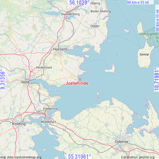
Juelsminde GPS coordinates[2]
55° 42' 31.536" North, 10° 1' 0.048" East
| Map corner | latitude | longitude |
|---|---|---|
| Upper-left | 56.1029°, | 9.31356° |
| Center: | 55.70876°, | 10.01668° |
| Lower-right: | 55.31061°, | 10.71981° |
| Map W x H: | 88.1×88.1 km | = 54.7×54.7mi |
| max Lat: | 57.72093° ⇑52.3% North |
| Juelsminde: | 55.70876° |
| min Lat: | ⇓47.7% South 54.57644° |
| min Long | Juelsminde | max Long |
| 8.12605° | 10.01668° | 15.18662° |
| W 39.5%⇐ | ⇒60.5% E |
Elevation
Elevation of Juelsminde is 2 m = 7 ft, and this is 25.3 m = 83 ft below average elevation for this country.
| Max E: |
114 m = 374 ft | 98% |
| Avg. | 27.3 m = 90 ft | |
| Juelsminde | 2 m = 7 ft | |
Min E: |
0 m = 0 ft | 2% |
See also: Denmark elevation on elevation.city.
Geographical zone
Juelsminde is located in North temperate zone (between Tropic of Cancer and the Arctic Circle). Distance of this North polar circle is 1206.9 km =749.9 mi to North.| Distance of | km | miles | from Juelsminde |
|---|---|---|---|
| North Pole | 3812.8 | 2369.2 | to North |
| Arctic Circle | 1206.9 | 749.9 | to North |
| Tropic Cancer | 3588.3 | 2229.7 | to South |
| Equator | 6194.2 | 3848.9 | to South |


Nearby cities:
15 places around Juelsminde: (largest is in red/bold)
• Bogense
16.4 km =10.2 mi,  164°
164°
• Brejning
22.1 km =13.7 mi,  257°
257°
• Brenderup
25.1 km =15.6 mi,  185°
185°
• Børkop
24.2 km =15 mi,  252°
252°
• Fredericia
23 km =14.3 mi,  226°
226°
• Harndrup
26.9 km =16.7 mi,  179°
179°
• Hedensted
20.9 km =13 mi,  289°
289°
• Hornsyld
11.3 km =7 mi,  297°
297°
• Horsens
19.8 km =12.3 mi,  328°
328°
• Middelfart
28.8 km =17.9 mi,  218°
218°
• Nørre Åby
28.9 km =18 mi,  197°
197°
• Snoghøj
27.8 km =17.3 mi, 221°
• Strib
24.4 km =15.2 mi, 219°
• Søndersø
29 km =18 mi,  148°
148°
• Vejle
30.1 km =18.7 mi,  270°
270°
Sources, notices
• [Note1] Compared only with cities in Denmark existing in our database
• [Src1] Map data: © OpenStreetMap contributors (CC-BY-SA)
• [Src2] Other city data from geonames.org with taken over terms of usage.
• [Src3] Geographical zone / Annual Mean Temperature by Robert A. Rohde @ Wikipedia
