Assens geodata
Assens (South Denmark) is a seat of a second-order administrative division; located in Denmark in Europe/Copenhagen (GMT+2) time zone. With population of 6,053 people, there are 116 cities with bigger population in this country. Compared to other cities in Denmark, 83.3% of cities are located further ↑North; 65.5% of cities are located further →East and 67% of cities have higher elevation than Assens. Note1


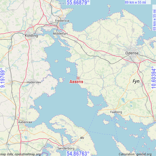
Assens GPS coordinates[2]
55° 16' 12.828" North, 9° 54' 2.916" East
| Map corner | latitude | longitude |
|---|---|---|
| Upper-left | 55.66879°, | 9.19769° |
| Center: | 55.27023°, | 9.90081° |
| Lower-right: | 54.86763°, | 10.60394° |
| Map W x H: | 89.1×89.1 km | = 55.4×55.4mi |
| max Lat: | 57.72093° ⇑83.3% North |
| Assens: | 55.27023° |
| min Lat: | ⇓16.7% South 54.57644° |
| min Long | Assens | max Long |
| 8.12605° | 9.90081° | 15.18662° |
| W 34.5%⇐ | ⇒65.5% E |
Elevation
Elevation of Assens is 14 m = 46 ft, and this is 13.3 m = 44 ft below average elevation for this country.
| Max E: |
114 m = 374 ft | 67% |
| Avg. | 27.3 m = 90 ft | |
| Assens | 14 m = 46 ft | |
Min E: |
0 m = 0 ft | 33% |
See also: Denmark elevation on elevation.city.
Geographical zone
Assens is located in North temperate zone (between Tropic of Cancer and the Arctic Circle). Distance of this North polar circle is 1255.7 km =780.3 mi to North.| Distance of | km | miles | from Assens |
|---|---|---|---|
| North Pole | 3861.6 | 2399.5 | to North |
| Arctic Circle | 1255.7 | 780.3 | to North |
| Tropic Cancer | 3539.6 | 2199.4 | to South |
| Equator | 6145.5 | 3818.6 | to South |


Nearby cities:
15 places around Assens: (largest is in red/bold)
• Bellinge
27.5 km =17.1 mi,  74°
74°
• Brenderup
24.3 km =15.1 mi,  11°
11°
• Christiansfeld
27.9 km =17.3 mi,  290°
290°
• Ejby
17.9 km =11.1 mi, 5°
• Glamsbjerg
12.9 km =8 mi,  88°
88°
• Haderslev
26.3 km =16.3 mi,  264°
264°
• Harndrup
23.1 km =14.4 mi,  19°
19°
• Hårby
15 km =9.3 mi,  110°
110°
• Nordborg
25.8 km =16 mi,  203°
203°
• Nørre Åby
21.3 km =13.2 mi,  356°
356°
• Starup
23.4 km =14.5 mi, 262°
• Tommerup
20.1 km =12.5 mi, 74°
• Tommerup Stationsby
19.3 km =12 mi,  64°
64°
• Vissenbjerg
19.7 km =12.2 mi,  49°
49°
• Årup
14.5 km =9 mi,  37°
37°
Sources, notices
• [Note1] Compared only with cities in Denmark existing in our database
• [Src1] Map data: © OpenStreetMap contributors (CC-BY-SA)
• [Src2] Other city data from geonames.org with taken over terms of usage.
• [Src3] Geographical zone / Annual Mean Temperature by Robert A. Rohde @ Wikipedia
