Viborg geodata
Viborg (Central Jutland) is a seat of a first-order administrative division; located in Denmark in Europe/Copenhagen (GMT+2) time zone. With population of 34,831 people, there are 22 cities with bigger population in this country. Compared to other cities in Denmark, 83.6% of cities are located further ↓South; 81.6% of cities are located further →East and 83.6% of cities have lower elevation than Viborg. Note1


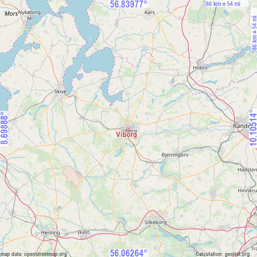
Viborg GPS coordinates[2]
56° 27' 11.484" North, 9° 24' 7.236" East
| Map corner | latitude | longitude |
|---|---|---|
| Upper-left | 56.83977°, | 8.69888° |
| Center: | 56.45319°, | 9.40201° |
| Lower-right: | 56.06264°, | 10.10514° |
| Map W x H: | 86.4×86.4 km | = 53.7×53.7mi |
| max Lat: | 57.72093° ⇑16.4% North |
| Viborg: | 56.45319° |
| min Lat: | ⇓83.6% South 54.57644° |
| min Long | Viborg | max Long |
| 8.12605° | 9.40201° | 15.18662° |
| W 18.4%⇐ | ⇒81.6% E |
Elevation
Elevation of Viborg is 50 m = 164 ft, and this is 22.7 m = 74 ft above average elevation for this country.
| Max E: |
114 m = 374 ft | 16.4% |
| Viborg | 50 m 164 ft | |
| Avg. | 27.3 m = 90 ft | |
Min E: |
0 m = 0 ft | 83.6% |
See also: Denmark elevation on elevation.city.
Geographical zone
Viborg is located in North temperate zone (between Tropic of Cancer and the Arctic Circle). Distance of this North polar circle is 1124.2 km =698.5 mi to North.| Distance of | km | miles | from Viborg |
|---|---|---|---|
| North Pole | 3730.1 | 2317.8 | to North |
| Arctic Circle | 1124.2 | 698.5 | to North |
| Tropic Cancer | 3671.1 | 2281.1 | to South |
| Equator | 6277 | 3900.3 | to South |


Nearby cities:
15 places around Viborg: (largest is in red/bold)
• Bjerringbro
18 km =11.2 mi,  117°
117°
• Bording Kirkeby
33.1 km =20.6 mi,  197°
197°
• Farsø
35.7 km =22.2 mi,  353°
353°
• Hammel
35.8 km =22.2 mi,  127°
127°
• Hobro
31.8 km =19.8 mi,  48°
48°
• Karup
21.7 km =13.5 mi,  221°
221°
• Kjellerup
18.7 km =11.6 mi,  173°
173°
• Langå
31.1 km =19.3 mi,  102°
102°
• Silkeborg
32.7 km =20.3 mi,  164°
164°
• Skive
26.3 km =16.3 mi,  298°
298°
• Stoholm
16.1 km =10 mi,  282°
282°
• Sunds
36.3 km =22.6 mi, 221°
• Ulstrup
25.1 km =15.6 mi,  106°
106°
• Virklund
36.9 km =22.9 mi, 165°
• Ålestrup
27.4 km =17 mi,  11°
11°
Sources, notices
• [Note1] Compared only with cities in Denmark existing in our database
• [Src1] Map data: © OpenStreetMap contributors (CC-BY-SA)
• [Src2] Other city data from geonames.org with taken over terms of usage.
• [Src3] Geographical zone / Annual Mean Temperature by Robert A. Rohde @ Wikipedia
