Sabana Grande de Boyá geodata
Sabana Grande de Boyá (Monte Plata) is a populated place; located in Dominican Republic in America/Santo_Domingo (GMT-4) time zone. With population of 16,834 people, there are 44 cities with bigger population in this country. Compared to other cities in Dominican Republic, 53.1% of cities are located further ↓South; 87.2% of cities are located further ←West and 80.6% of cities have lower elevation than Sabana Grande de Boyá. Note1
Administrative division(s):
- Level 1: Monte Plata
- Level 2: Sabana Grande de Boyá
- Level 3: Sabana Grande De Boyá
- Level 4: Sabana Grande De Boyá (Zona Urbana)
Current local time in Sabana Grande de Boyá:
09:05 AM, ThursdayDifference from your time zone: hours


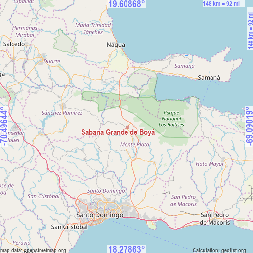
Sabana Grande de Boyá GPS coordinates[2]
18° 56' 41.928" North, 69° 47' 35.916" West
| Map corner | latitude | longitude |
|---|---|---|
| Upper-left | 19.60868°, | -70.49644° |
| Center: | 18.94498°, | -69.79331° |
| Lower-right: | 18.27863°, | -69.09019° |
| Map W x H: | 147.9×147.9 km | = 91.9×91.9mi |
| max Lat: | 19.89131° ⇑46.9% North |
| Sabana Grande de Boyá: | 18.94498° |
| min Lat: | ⇓53.1% South 17.80136° |
| min Long | Sabana Grande d | max Long |
| -71.85022° | -69.79331° | -68.40431° |
| W 87.2%⇐ | ⇒12.8% E |
Elevation
Elevation of Sabana Grande de Boyá is 291 m = 955 ft, and this is 124.7 m = 409 ft above average elevation for this country.
| Max E: |
1242 m = 4075 ft | 19.4% |
| Sabana Grande de Boyá | 291 m 955 ft | |
| Avg. | 166.3 m = 546 ft | |
Min E: |
5 m = 16 ft | 80.6% |
See also: Dominican Republic elevation on elevation.city.
Geographical zone
Sabana Grande de Boyá is located in North Torrid zone (between Equator and Tropic of Cancer). Distance of this Northern Tropic circle is 499.4 km =310.3 mi to North.| Distance of | km | miles | from Sabana Grande de Boyá |
|---|---|---|---|
| North Pole | 7900.6 | 4909.2 | to North |
| Arctic Circle | 5294.7 | 3290 | to North |
| Tropic Cancer | 499.4 | 310.3 | to North |
| Equator | 2106.5 | 1308.9 | to South |


Nearby cities:
15 places around Sabana Grande de Boyá: (largest is in red/bold)
• Agua Santa del Yuna
22.9 km =14.2 mi,  358°
358°
• Arenoso
27.8 km =17.3 mi,  345°
345°
• Bayaguana
27.3 km =17 mi,  142°
142°
• Castillo
38.2 km =23.7 mi,  319°
319°
• Cevicos
20.6 km =12.8 mi,  288°
288°
• Don Juan
20.7 km =12.9 mi,  230°
230°
• Esperalvillo
29.3 km =18.2 mi,  240°
240°
• Gonzalo
4.5 km =2.8 mi,  80°
80°
• Hostos
35.4 km =22 mi, 317°
• Los Botados
31.8 km =19.8 mi,  221°
221°
• Majagual
11.6 km =7.2 mi,  337°
337°
• Monte Plata
15.4 km =9.6 mi,  176°
176°
• Sánchez
36.7 km =22.8 mi,  30°
30°
• Villa Riva
29.1 km =18.1 mi,  334°
334°
• Yamasá
31 km =19.3 mi, 232°
Sources, notices
• [Note1] Compared only with cities in Dominican Republic existing in our database
• [Src1] Map data: © OpenStreetMap contributors (CC-BY-SA)
• [Src2] Other city data from geonames.org with taken over terms of usage.
• [Src3] Geographical zone / Annual Mean Temperature by Robert A. Rohde @ Wikipedia
