Samaná geodata
Samaná is a seat of a first-order administrative division; located in Dominican Republic in America/Santo_Domingo (GMT-4) time zone. With population of 11,432 people, there are 60 cities with bigger population in this country. Compared to other cities in Dominican Republic, 63.5% of cities are located further ↓South; 93.4% of cities are located further ←West and 87.2% of cities have higher elevation than Samaná. Note1
Administrative division(s):
- Level 1: Samaná
- Level 2: Samaná Municipality
- Level 3: Samaná
- Level 4: Santa Bárbara De Samaná (Zona Urbana)


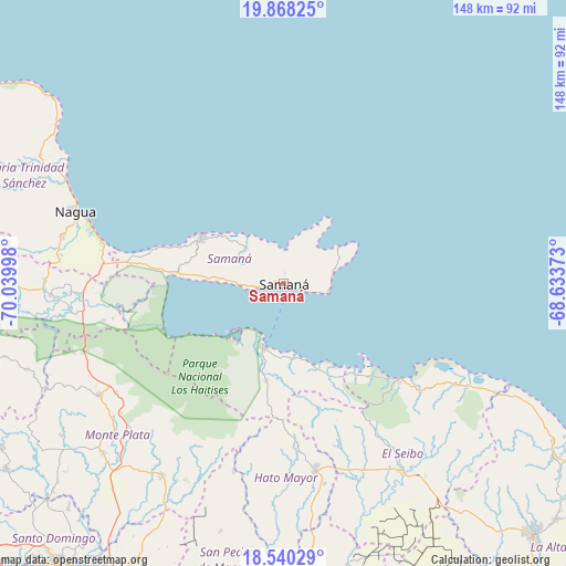
Samaná GPS coordinates[2]
19° 12' 20.196" North, 69° 20' 12.66" West
| Map corner | latitude | longitude |
|---|---|---|
| Upper-left | 19.86825°, | -70.03998° |
| Center: | 19.20561°, | -69.33685° |
| Lower-right: | 18.54029°, | -68.63373° |
| Map W x H: | 147.7×147.7 km | = 91.8×91.8mi |
| max Lat: | 19.89131° ⇑36.5% North |
| Samaná: | 19.20561° |
| min Lat: | ⇓63.5% South 17.80136° |
| min Long | Samaná | max Long |
| -71.85022° | -69.33685° | -68.40431° |
| W 93.4%⇐ | ⇒6.6% E |
Elevation
Elevation of Samaná is 15 m = 49 ft, and this is 151.3 m = 496 ft below average elevation for this country.
| Max E: |
1242 m = 4075 ft | 87.2% |
| Avg. | 166.3 m = 546 ft | |
| Samaná | 15 m = 49 ft | |
Min E: |
5 m = 16 ft | 12.8% |
See also: Dominican Republic elevation on elevation.city.
Geographical zone
Samaná is located in North Torrid zone (between Equator and Tropic of Cancer). Distance of this Northern Tropic circle is 470.5 km =292.4 mi to North.| Distance of | km | miles | from Samaná |
|---|---|---|---|
| North Pole | 7871.6 | 4891.2 | to North |
| Arctic Circle | 5265.7 | 3272 | to North |
| Tropic Cancer | 470.5 | 292.4 | to North |
| Equator | 2135.5 | 1326.9 | to South |


Nearby cities:
15 places around Samaná: (largest is in red/bold)
• Agua Santa del Yuna
49.1 km =30.5 mi,  262°
262°
• Arenoso
54.9 km =34.1 mi,  267°
267°
• El Puerto
48.9 km =30.4 mi,  196°
196°
• El Valle
25.9 km =16.1 mi,  189°
189°
• Gonzalo
51.9 km =32.2 mi,  237°
237°
• Hato Mayor del Rey
50 km =31.1 mi,  170°
170°
• Las Terrenas
24.6 km =15.3 mi,  298°
298°
• Majagual
55.5 km =34.5 mi,  250°
250°
• Miches
39.2 km =24.4 mi,  129°
129°
• Nagua
57.1 km =35.5 mi,  290°
290°
• Pedro Sánchez
44.9 km =27.9 mi,  147°
147°
• Sabana Grande de Boyá
56 km =34.8 mi, 238°
• Sabana de la Mar
17.1 km =10.6 mi, 198°
• Santa Cruz de El Seibo
58.1 km =36.1 mi, 147°
• Sánchez
29.2 km =18.1 mi, 274°
Sources, notices
• [Note1] Compared only with cities in Dominican Republic existing in our database
• [Src1] Map data: © OpenStreetMap contributors (CC-BY-SA)
• [Src2] Other city data from geonames.org with taken over terms of usage.
• [Src3] Geographical zone / Annual Mean Temperature by Robert A. Rohde @ Wikipedia
