Nagua geodata
Nagua (María Trinidad Sánchez) is a seat of a first-order administrative division; located in Dominican Republic in America/Santo_Domingo (GMT-4) time zone. With population of 33,862 people, there are 28 cities with bigger population in this country. Compared to other cities in Dominican Republic, 73.5% of cities are located further ↓South; 85.8% of cities are located further ←West and 96.7% of cities have higher elevation than Nagua. Note1
Administrative division(s):
- Level 1: María Trinidad Sánchez
- Level 2: Nagua
- Level 3: Nagua
- Level 4: Nagua (Zona Urbana)


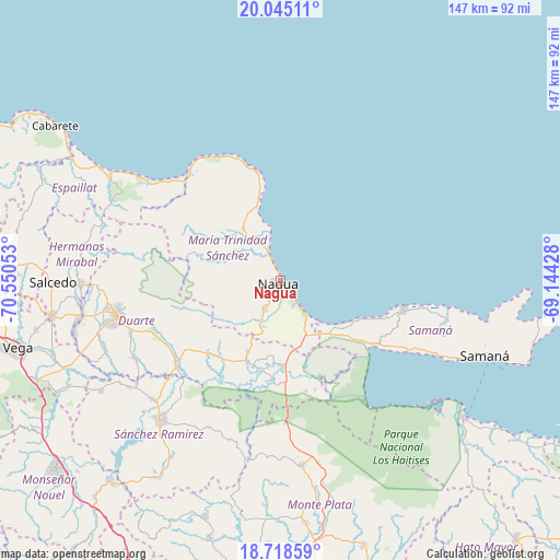
Nagua GPS coordinates[2]
19° 22' 59.52" North, 69° 50' 50.64" West
| Map corner | latitude | longitude |
|---|---|---|
| Upper-left | 20.04511°, | -70.55053° |
| Center: | 19.3832°, | -69.8474° |
| Lower-right: | 18.71859°, | -69.14428° |
| Map W x H: | 147.5×147.5 km | = 91.7×91.7mi |
| max Lat: | 19.89131° ⇑26.5% North |
| Nagua: | 19.3832° |
| min Lat: | ⇓73.5% South 17.80136° |
| min Long | Nagua | max Long |
| -71.85022° | -69.8474° | -68.40431° |
| W 85.8%⇐ | ⇒14.2% E |
Elevation
Elevation of Nagua is 9 m = 30 ft, and this is 157.3 m = 516 ft below average elevation for this country.
| Max E: |
1242 m = 4075 ft | 96.7% |
| Avg. | 166.3 m = 546 ft | |
| Nagua | 9 m = 30 ft | |
Min E: |
5 m = 16 ft | 3.3% |
See also: Dominican Republic elevation on elevation.city.
Geographical zone
Nagua is located in North Torrid zone (between Equator and Tropic of Cancer). Distance of this Northern Tropic circle is 450.7 km =280.1 mi to North.| Distance of | km | miles | from Nagua |
|---|---|---|---|
| North Pole | 7851.9 | 4878.9 | to North |
| Arctic Circle | 5246 | 3259.7 | to North |
| Tropic Cancer | 450.7 | 280.1 | to North |
| Equator | 2155.2 | 1339.2 | to South |


Nearby cities:
15 places around Nagua: (largest is in red/bold)
• Agua Santa del Yuna
26.3 km =16.3 mi,  169°
169°
• Arenoso
21.8 km =13.5 mi,  183°
183°
• Arroyo Salado
14.1 km =8.8 mi,  336°
336°
• Cabrera
29.5 km =18.3 mi,  348°
348°
• Castillo
27.1 km =16.8 mi,  224°
224°
• El Factor
8.4 km =5.2 mi,  210°
210°
• Hostos
29 km =18 mi, 218°
• La Entrada
20 km =12.4 mi, 341°
• La Peña
36 km =22.4 mi,  250°
250°
• Las Terrenas
32.9 km =20.4 mi,  104°
104°
• Majagual
38 km =23.6 mi, 178°
• Pimentel
35.3 km =21.9 mi,  231°
231°
• Río San Juan
37.6 km =23.4 mi,  320°
320°
• Sánchez
30 km =18.6 mi,  125°
125°
• Villa Riva
23.6 km =14.7 mi,  197°
197°
Sources, notices
• [Note1] Compared only with cities in Dominican Republic existing in our database
• [Src1] Map data: © OpenStreetMap contributors (CC-BY-SA)
• [Src2] Other city data from geonames.org with taken over terms of usage.
• [Src3] Geographical zone / Annual Mean Temperature by Robert A. Rohde @ Wikipedia
