Majagual geodata
Majagual (Monte Plata) is a populated place; located in Dominican Republic in America/Santo_Domingo (GMT-4) time zone. With population of 1,430 people, there are 196 cities with bigger population in this country. Compared to other cities in Dominican Republic, 55.9% of cities are located further ↓South; 86.3% of cities are located further ←West and 76.3% of cities have lower elevation than Majagual. Note1
Administrative division(s):
- Level 1: Monte Plata
- Level 2: Sabana Grande de Boyá
- Level 3: Majagual (D. M.).
- Level 4: Majagual (Zona Urbana)


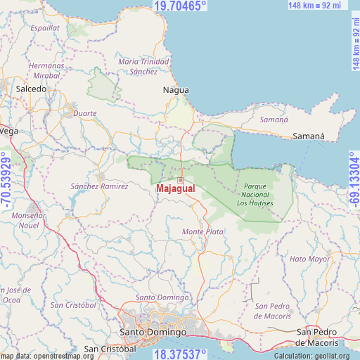
Majagual GPS coordinates[2]
19° 2' 28.824" North, 69° 50' 10.176" West
| Map corner | latitude | longitude |
|---|---|---|
| Upper-left | 19.70465°, | -70.53929° |
| Center: | 19.04134°, | -69.83616° |
| Lower-right: | 18.37537°, | -69.13304° |
| Map W x H: | 147.8×147.8 km | = 91.8×91.8mi |
| max Lat: | 19.89131° ⇑44.1% North |
| Majagual: | 19.04134° |
| min Lat: | ⇓55.9% South 17.80136° |
| min Long | Majagual | max Long |
| -71.85022° | -69.83616° | -68.40431° |
| W 86.3%⇐ | ⇒13.7% E |
Elevation
Elevation of Majagual is 226 m = 741 ft, and this is 59.7 m = 196 ft above average elevation for this country.
| Max E: |
1242 m = 4075 ft | 23.7% |
| Majagual | 226 m 741 ft | |
| Avg. | 166.3 m = 546 ft | |
Min E: |
5 m = 16 ft | 76.3% |
See also: Dominican Republic elevation on elevation.city.
Geographical zone
Majagual is located in North Torrid zone (between Equator and Tropic of Cancer). Distance of this Northern Tropic circle is 488.7 km =303.7 mi to North.| Distance of | km | miles | from Majagual |
|---|---|---|---|
| North Pole | 7889.9 | 4902.6 | to North |
| Arctic Circle | 5284 | 3283.3 | to North |
| Tropic Cancer | 488.7 | 303.7 | to North |
| Equator | 2117.2 | 1315.6 | to South |


Nearby cities:
15 places around Majagual: (largest is in red/bold)
• Agua Santa del Yuna
12.7 km =7.9 mi,  17°
17°
• Arenoso
16.4 km =10.2 mi,  351°
351°
• Castillo
27.3 km =17 mi,  312°
312°
• Cevicos
15.6 km =9.7 mi,  254°
254°
• Cotuí
32.9 km =20.4 mi,  272°
272°
• Don Juan
26.4 km =16.4 mi,  205°
205°
• El Factor
31.3 km =19.4 mi, 349°
• Esperalvillo
32.8 km =20.4 mi,  219°
219°
• Gonzalo
13.4 km =8.3 mi,  138°
138°
• Hostos
24.8 km =15.4 mi, 308°
• Monte Plata
26.6 km =16.5 mi,  168°
168°
• Pimentel
32.8 km =20.4 mi,  299°
299°
• Sabana Grande de Boyá
11.6 km =7.2 mi,  157°
157°
• Sánchez
31.3 km =19.4 mi,  48°
48°
• Villa Riva
17.5 km =10.9 mi,  332°
332°
Sources, notices
• [Note1] Compared only with cities in Dominican Republic existing in our database
• [Src1] Map data: © OpenStreetMap contributors (CC-BY-SA)
• [Src2] Other city data from geonames.org with taken over terms of usage.
• [Src3] Geographical zone / Annual Mean Temperature by Robert A. Rohde @ Wikipedia
