Las Terrenas geodata
Las Terrenas (Samaná) is a populated place; located in Dominican Republic in America/Santo_Domingo (GMT-4) time zone. With population of 7,713 people, there are 79 cities with bigger population in this country. Compared to other cities in Dominican Republic, 68.2% of cities are located further ↓South; 90.5% of cities are located further ←West and 84.4% of cities have higher elevation than Las Terrenas. Note1
Administrative division(s):
- Level 1: Samaná
- Level 2: Las Terrenas
- Level 3: Las Terrenas
- Level 4: Las Terrenas (Zona Urbana)


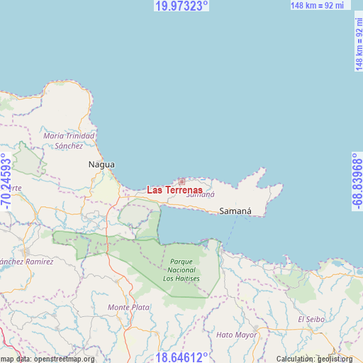
Las Terrenas GPS coordinates[2]
19° 18' 39.672" North, 69° 32' 34.08" West
| Map corner | latitude | longitude |
|---|---|---|
| Upper-left | 19.97323°, | -70.24593° |
| Center: | 19.31102°, | -69.5428° |
| Lower-right: | 18.64612°, | -68.83968° |
| Map W x H: | 147.6×147.6 km | = 91.7×91.7mi |
| max Lat: | 19.89131° ⇑31.8% North |
| Las Terrenas: | 19.31102° |
| min Lat: | ⇓68.2% South 17.80136° |
| min Long | Las Terrenas | max Long |
| -71.85022° | -69.5428° | -68.40431° |
| W 90.5%⇐ | ⇒9.5% E |
Elevation
Elevation of Las Terrenas is 17 m = 56 ft, and this is 149.3 m = 490 ft below average elevation for this country.
| Max E: |
1242 m = 4075 ft | 84.4% |
| Avg. | 166.3 m = 546 ft | |
| Las Terrenas | 17 m = 56 ft | |
Min E: |
5 m = 16 ft | 15.6% |
See also: Dominican Republic elevation on elevation.city.
Geographical zone
Las Terrenas is located in North Torrid zone (between Equator and Tropic of Cancer). Distance of this Northern Tropic circle is 458.7 km =285 mi to North.| Distance of | km | miles | from Las Terrenas |
|---|---|---|---|
| North Pole | 7859.9 | 4883.9 | to North |
| Arctic Circle | 5254 | 3264.7 | to North |
| Tropic Cancer | 458.7 | 285 | to North |
| Equator | 2147.2 | 1334.2 | to South |


Nearby cities:
15 places around Las Terrenas: (largest is in red/bold)
• Agua Santa del Yuna
32.4 km =20.1 mi,  236°
236°
• Arenoso
35.9 km =22.3 mi,  247°
247°
• Arroyo Salado
43 km =26.7 mi,  299°
299°
• Castillo
52.1 km =32.4 mi,  257°
257°
• El Factor
36.3 km =22.6 mi,  271°
271°
• El Valle
41.1 km =25.5 mi,  155°
155°
• Gonzalo
45.6 km =28.3 mi,  208°
208°
• La Entrada
46.8 km =29.1 mi,  305°
305°
• Majagual
43 km =26.7 mi,  225°
225°
• Nagua
32.9 km =20.4 mi,  284°
284°
• Sabana Grande de Boyá
48.5 km =30.1 mi, 212°
• Sabana de la Mar
32.3 km =20.1 mi,  149°
149°
• Samaná
24.6 km =15.3 mi,  118°
118°
• Sánchez
11.8 km =7.3 mi,  218°
218°
• Villa Riva
41.5 km =25.8 mi, 249°
Sources, notices
• [Note1] Compared only with cities in Dominican Republic existing in our database
• [Src1] Map data: © OpenStreetMap contributors (CC-BY-SA)
• [Src2] Other city data from geonames.org with taken over terms of usage.
• [Src3] Geographical zone / Annual Mean Temperature by Robert A. Rohde @ Wikipedia
