Puerto Plata geodata
Puerto Plata is a seat of a first-order administrative division; located in Dominican Republic in America/Santo_Domingo (GMT-4) time zone. With population of 146,000 people, there are 8 cities with bigger population in this country. Compared to other cities in Dominican Republic, 98.1% of cities are located further ↓South; 53.1% of cities are located further →East and 70.1% of cities have higher elevation than Puerto Plata. Note1
Administrative division(s):
- Level 1: Puerto Plata
- Level 2: Puerto Plata
- Level 3: Puerto Plata
- Level 4: San Felipe De Puerto Plata (Zona Urbana)


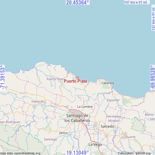
Puerto Plata GPS coordinates[2]
19° 47' 36.384" North, 70° 41' 18.24" West
| Map corner | latitude | longitude |
|---|---|---|
| Upper-left | 20.45364°, | -71.39153° |
| Center: | 19.79344°, | -70.6884° |
| Lower-right: | 19.13049°, | -69.98528° |
| Map W x H: | 147.1×147.1 km | = 91.4×91.4mi |
| max Lat: | 19.89131° ⇑1.9% North |
| Puerto Plata: | 19.79344° |
| min Lat: | ⇓98.1% South 17.80136° |
| min Long | Puerto Plata | max Long |
| -71.85022° | -70.6884° | -68.40431° |
| W 46.9%⇐ | ⇒53.1% E |
Elevation
Elevation of Puerto Plata is 34 m = 112 ft, and this is 132.3 m = 434 ft below average elevation for this country.
| Max E: |
1242 m = 4075 ft | 70.1% |
| Avg. | 166.3 m = 546 ft | |
| Puerto Plata | 34 m = 112 ft | |
Min E: |
5 m = 16 ft | 29.9% |
See also: Puerto Plata elevation on elevation.city.
Geographical zone
Puerto Plata is located in North Torrid zone (between Equator and Tropic of Cancer). Distance of this Northern Tropic circle is 405.1 km =251.7 mi to North.| Distance of | km | miles | from Puerto Plata |
|---|---|---|---|
| North Pole | 7806.2 | 4850.5 | to North |
| Arctic Circle | 5200.3 | 3231.3 | to North |
| Tropic Cancer | 405.1 | 251.7 | to North |
| Equator | 2200.8 | 1367.5 | to South |


Nearby cities:
15 places around Puerto Plata: (largest is in red/bold)
• Altamira
20.8 km =12.9 mi,  231°
231°
• Cabarete
29.7 km =18.5 mi,  99°
99°
• Guananico
25.6 km =15.9 mi,  253°
253°
• Imbert
15.4 km =9.6 mi, 253°
• Jamao al Norte
30.8 km =19.1 mi,  124°
124°
• Jicomé
31.6 km =19.6 mi,  239°
239°
• Luperón
30.6 km =19 mi,  290°
290°
• Monte Llano
11.4 km =7.1 mi,  125°
125°
• Palmar Arriba
28.7 km =17.8 mi,  190°
190°
• Pedro García
22.7 km =14.1 mi,  170°
170°
• Río Grande
16.3 km =10.1 mi,  210°
210°
• Sosúa
18.2 km =11.3 mi, 104°
• Tamboril
35.2 km =21.9 mi, 166°
• Villa Bisonó
32.2 km =20 mi,  217°
217°
• Villa González
30 km =18.6 mi,  200°
200°
In other languages:
- In Spanish: San Felipe de Puerto Plata
- In Italian: San Felipe de Puerto Plata
- In Russian: Сан-Фелипе-де-Пуэрто-Плата
- In Chinese: 聖斐利-銀港
Sources, notices
• [Note1] Compared only with cities in Dominican Republic existing in our database
• [Src1] Map data: © OpenStreetMap contributors (CC-BY-SA)
• [Src2] Other city data from geonames.org with taken over terms of usage.
• [Src3] Geographical zone / Annual Mean Temperature by Robert A. Rohde @ Wikipedia
