Imbert geodata
Imbert (Puerto Plata) is a populated place; located in Dominican Republic in America/Santo_Domingo (GMT-4) time zone. With population of 8,024 people, there are 78 cities with bigger population in this country. Compared to other cities in Dominican Republic, 97.6% of cities are located further ↓South; 59.7% of cities are located further →East and 63.5% of cities have lower elevation than Imbert. Note1
Administrative division(s):
- Level 1: Puerto Plata
- Level 2: Imbert
- Level 3: Imbert
- Level 4: Imbert (Zona Urbana)


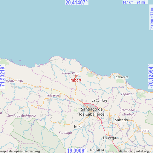
Imbert GPS coordinates[2]
19° 45' 13.356" North, 70° 49' 44.616" West
| Map corner | latitude | longitude |
|---|---|---|
| Upper-left | 20.41407°, | -71.53219° |
| Center: | 19.75371°, | -70.82906° |
| Lower-right: | 19.0906°, | -70.12594° |
| Map W x H: | 147.2×147.2 km | = 91.5×91.5mi |
| max Lat: | 19.89131° ⇑2.4% North |
| Imbert: | 19.75371° |
| min Lat: | ⇓97.6% South 17.80136° |
| min Long | Imbert | max Long |
| -71.85022° | -70.82906° | -68.40431° |
| W 40.3%⇐ | ⇒59.7% E |
Elevation
Elevation of Imbert is 121 m = 397 ft, and this is 45.3 m = 149 ft below average elevation for this country.
| Max E: |
1242 m = 4075 ft | 36.5% |
| Avg. | 166.3 m = 546 ft | |
| Imbert | 121 m = 397 ft | |
Min E: |
5 m = 16 ft | 63.5% |
See also: Dominican Republic elevation on elevation.city.
Geographical zone
Imbert is located in North Torrid zone (between Equator and Tropic of Cancer). Distance of this Northern Tropic circle is 409.5 km =254.5 mi to North.| Distance of | km | miles | from Imbert |
|---|---|---|---|
| North Pole | 7810.7 | 4853.3 | to North |
| Arctic Circle | 5204.8 | 3234.1 | to North |
| Tropic Cancer | 409.5 | 254.5 | to North |
| Equator | 2196.4 | 1364.8 | to South |


Nearby cities:
15 places around Imbert: (largest is in red/bold)
• Altamira
8.6 km =5.3 mi,  190°
190°
• Esperanza
24.9 km =15.5 mi,  220°
220°
• Guananico
10.3 km =6.4 mi,  253°
253°
• Jicomé
17.1 km =10.6 mi,  227°
227°
• Los Hidalgos
21.5 km =13.4 mi,  263°
263°
• Luperón
20.7 km =12.9 mi,  317°
317°
• Maizal
24.5 km =15.2 mi,  237°
237°
• Monte Llano
24.2 km =15 mi,  95°
95°
• Palmar Arriba
25.6 km =15.9 mi,  158°
158°
• Pedro García
25.8 km =16 mi,  134°
134°
• Puerto Plata
15.4 km =9.6 mi,  73°
73°
• Río Grande
11.7 km =7.3 mi,  145°
145°
• Villa Bisonó
21.7 km =13.5 mi, 193°
• Villa González
24.1 km =15 mi,  169°
169°
• Villa Isabela
25.2 km =15.7 mi,  285°
285°
Sources, notices
• [Note1] Compared only with cities in Dominican Republic existing in our database
• [Src1] Map data: © OpenStreetMap contributors (CC-BY-SA)
• [Src2] Other city data from geonames.org with taken over terms of usage.
• [Src3] Geographical zone / Annual Mean Temperature by Robert A. Rohde @ Wikipedia
