La Entrada geodata
La Entrada (María Trinidad Sánchez) is a populated place; located in Dominican Republic in America/Santo_Domingo (GMT-4) time zone. With population of 1,112 people, there are 203 cities with bigger population in this country. Compared to other cities in Dominican Republic, 83.9% of cities are located further ↓South; 80.1% of cities are located further ←West and 94.3% of cities have higher elevation than La Entrada. Note1
Administrative division(s):
- Level 1: María Trinidad Sánchez
- Level 2: Cabrera
- Level 3: La Entrada (D. M.).
- Level 4: La Entrada (Zona Urbana)


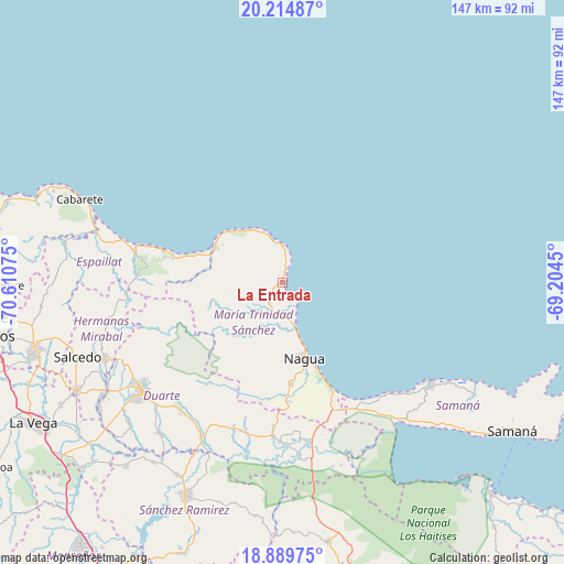
La Entrada GPS coordinates[2]
19° 33' 13.212" North, 69° 54' 27.432" West
| Map corner | latitude | longitude |
|---|---|---|
| Upper-left | 20.21487°, | -70.61075° |
| Center: | 19.55367°, | -69.90762° |
| Lower-right: | 18.88975°, | -69.2045° |
| Map W x H: | 147.3×147.3 km | = 91.5×91.5mi |
| max Lat: | 19.89131° ⇑16.1% North |
| La Entrada: | 19.55367° |
| min Lat: | ⇓83.9% South 17.80136° |
| min Long | La Entrada | max Long |
| -71.85022° | -69.90762° | -68.40431° |
| W 80.1%⇐ | ⇒19.9% E |
Elevation
Elevation of La Entrada is 10 m = 33 ft, and this is 156.3 m = 513 ft below average elevation for this country.
| Max E: |
1242 m = 4075 ft | 94.3% |
| Avg. | 166.3 m = 546 ft | |
| La Entrada | 10 m = 33 ft | |
Min E: |
5 m = 16 ft | 5.7% |
See also: Dominican Republic elevation on elevation.city.
Geographical zone
La Entrada is located in North Torrid zone (between Equator and Tropic of Cancer). Distance of this Northern Tropic circle is 431.8 km =268.3 mi to North.| Distance of | km | miles | from La Entrada |
|---|---|---|---|
| North Pole | 7832.9 | 4867.1 | to North |
| Arctic Circle | 5227 | 3247.9 | to North |
| Tropic Cancer | 431.8 | 268.3 | to North |
| Equator | 2174.2 | 1351 | to South |


Nearby cities:
15 places around La Entrada: (largest is in red/bold)
• Agua Santa del Yuna
46.2 km =28.7 mi,  165°
165°
• Arenoso
41.1 km =25.5 mi, 172°
• Arroyo Salado
6 km =3.7 mi, 172°
• Cabrera
9.9 km =6.2 mi,  1°
1°
• Castillo
40.4 km =25.1 mi,  198°
198°
• El Factor
26.2 km =16.3 mi,  175°
175°
• Gaspar Hernández
39.6 km =24.6 mi,  281°
281°
• Hostos
43.2 km =26.8 mi, 195°
• Joba Arriba
37.6 km =23.4 mi,  272°
272°
• La Peña
41.4 km =25.7 mi,  221°
221°
• Nagua
20 km =12.4 mi,  161°
161°
• Río San Juan
20.3 km =12.6 mi,  299°
299°
• San Francisco de Macorís
45.8 km =28.5 mi,  232°
232°
• Veragua Arriba
44.7 km =27.8 mi, 274°
• Villa Riva
41.5 km =25.8 mi, 180°
Sources, notices
• [Note1] Compared only with cities in Dominican Republic existing in our database
• [Src1] Map data: © OpenStreetMap contributors (CC-BY-SA)
• [Src2] Other city data from geonames.org with taken over terms of usage.
• [Src3] Geographical zone / Annual Mean Temperature by Robert A. Rohde @ Wikipedia
