Cabrera geodata
Cabrera (María Trinidad Sánchez) is a populated place; located in Dominican Republic in America/Santo_Domingo (GMT-4) time zone. With population of 4,947 people, there are 116 cities with bigger population in this country. Compared to other cities in Dominican Republic, 89.1% of cities are located further ↓South; 80.6% of cities are located further ←West and 82.5% of cities have higher elevation than Cabrera. Note1
Administrative division(s):
- Level 1: María Trinidad Sánchez
- Level 2: Cabrera
- Level 3: Cabrera
- Level 4: Cabrera (Zona Urbana)


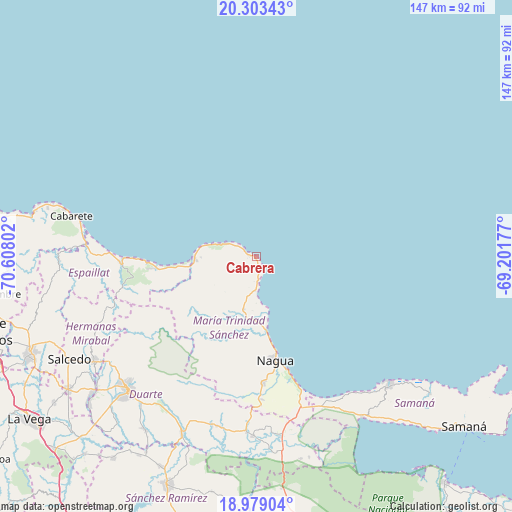
Cabrera GPS coordinates[2]
19° 38' 33.36" North, 69° 54' 17.604" West
| Map corner | latitude | longitude |
|---|---|---|
| Upper-left | 20.30343°, | -70.60802° |
| Center: | 19.6426°, | -69.90489° |
| Lower-right: | 18.97904°, | -69.20177° |
| Map W x H: | 147.3×147.3 km | = 91.5×91.5mi |
| max Lat: | 19.89131° ⇑10.9% North |
| Cabrera: | 19.6426° |
| min Lat: | ⇓89.1% South 17.80136° |
| min Long | Cabrera | max Long |
| -71.85022° | -69.90489° | -68.40431° |
| W 80.6%⇐ | ⇒19.4% E |
Elevation
Elevation of Cabrera is 22 m = 72 ft, and this is 144.3 m = 473 ft below average elevation for this country.
| Max E: |
1242 m = 4075 ft | 82.5% |
| Avg. | 166.3 m = 546 ft | |
| Cabrera | 22 m = 72 ft | |
Min E: |
5 m = 16 ft | 17.5% |
See also: Dominican Republic elevation on elevation.city.
Geographical zone
Cabrera is located in North Torrid zone (between Equator and Tropic of Cancer). Distance of this Northern Tropic circle is 421.9 km =262.2 mi to North.| Distance of | km | miles | from Cabrera |
|---|---|---|---|
| North Pole | 7823 | 4861 | to North |
| Arctic Circle | 5217.1 | 3241.8 | to North |
| Tropic Cancer | 421.9 | 262.2 | to North |
| Equator | 2184.1 | 1357.1 | to South |


Nearby cities:
15 places around Cabrera: (largest is in red/bold)
• Arenoso
50.8 km =31.6 mi,  174°
174°
• Arroyo Salado
15.9 km =9.9 mi,  178°
178°
• Castillo
50 km =31.1 mi,  194°
194°
• El Factor
36.1 km =22.4 mi, 177°
• Gaspar Hernández
39.1 km =24.3 mi,  267°
267°
• Hostos
52.8 km =32.8 mi, 193°
• Joba Arriba
38.8 km =24.1 mi,  257°
257°
• La Entrada
9.9 km =6.2 mi, 181°
• La Peña
49.4 km =30.7 mi,  214°
214°
• Las Terrenas
52.9 km =32.9 mi,  134°
134°
• Nagua
29.5 km =18.3 mi, 168°
• Río San Juan
18 km =11.2 mi, 270°
• San Francisco de Macorís
52.6 km =32.7 mi,  223°
223°
• Veragua Arriba
45.4 km =28.2 mi, 261°
• Villa Riva
51.4 km =31.9 mi, 180°
Sources, notices
• [Note1] Compared only with cities in Dominican Republic existing in our database
• [Src1] Map data: © OpenStreetMap contributors (CC-BY-SA)
• [Src2] Other city data from geonames.org with taken over terms of usage.
• [Src3] Geographical zone / Annual Mean Temperature by Robert A. Rohde @ Wikipedia
