Castillo geodata
Castillo (Duarte) is a populated place; located in Dominican Republic in America/Santo_Domingo (GMT-4) time zone. With population of 6,328 people, there are 94 cities with bigger population in this country. Compared to other cities in Dominican Republic, 64% of cities are located further ↓South; 74.4% of cities are located further ←West and 53.6% of cities have lower elevation than Castillo. Note1
Administrative division(s):
- Level 1: Duarte
- Level 2: Castillo
- Level 3: Castillo
- Level 4: Castillo (Zona Urbana)


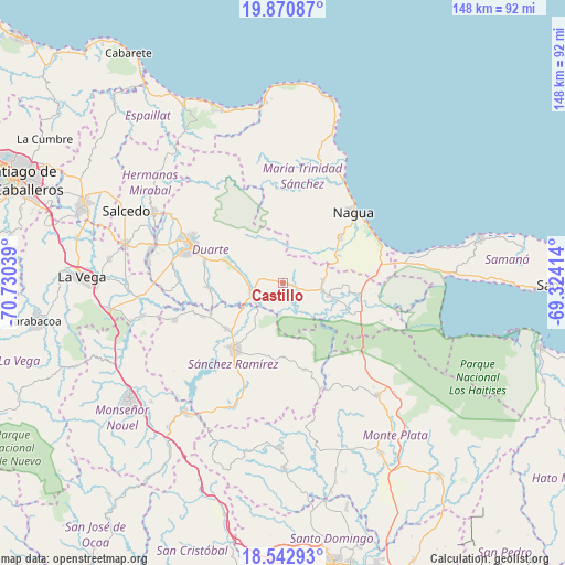
Castillo GPS coordinates[2]
19° 12' 29.664" North, 70° 1' 38.136" West
| Map corner | latitude | longitude |
|---|---|---|
| Upper-left | 19.87087°, | -70.73039° |
| Center: | 19.20824°, | -70.02726° |
| Lower-right: | 18.54293°, | -69.32414° |
| Map W x H: | 147.7×147.7 km | = 91.8×91.8mi |
| max Lat: | 19.89131° ⇑36% North |
| Castillo: | 19.20824° |
| min Lat: | ⇓64% South 17.80136° |
| min Long | Castillo | max Long |
| -71.85022° | -70.02726° | -68.40431° |
| W 74.4%⇐ | ⇒25.6% E |
Elevation
Elevation of Castillo is 80 m = 262 ft, and this is 86.3 m = 283 ft below average elevation for this country.
| Max E: |
1242 m = 4075 ft | 46.4% |
| Avg. | 166.3 m = 546 ft | |
| Castillo | 80 m = 262 ft | |
Min E: |
5 m = 16 ft | 53.6% |
See also: Dominican Republic elevation on elevation.city.
Geographical zone
Castillo is located in North Torrid zone (between Equator and Tropic of Cancer). Distance of this Northern Tropic circle is 470.2 km =292.2 mi to North.| Distance of | km | miles | from Castillo |
|---|---|---|---|
| North Pole | 7871.3 | 4891 | to North |
| Arctic Circle | 5265.4 | 3271.8 | to North |
| Tropic Cancer | 470.2 | 292.2 | to North |
| Equator | 2135.8 | 1327.1 | to South |


Nearby cities:
15 places around Castillo: (largest is in red/bold)
• Agua Santa del Yuna
24.6 km =15.3 mi,  105°
105°
• Arenoso
17.8 km =11.1 mi,  97°
97°
• Cevicos
23.2 km =14.4 mi,  167°
167°
• Cotuí
21.5 km =13.4 mi,  216°
216°
• El Factor
19 km =11.8 mi,  49°
49°
• Fantino
30.2 km =18.8 mi,  251°
251°
• Hostos
3.2 km =2 mi, 166°
• La Peña
17 km =10.6 mi,  296°
296°
• Las Guáranas
19.1 km =11.9 mi,  264°
264°
• Majagual
27.3 km =17 mi,  132°
132°
• Nagua
27.1 km =16.8 mi,  44°
44°
• Pimentel
9 km =5.6 mi, 252°
• San Francisco de Macorís
25.8 km =16 mi,  293°
293°
• Villa La Mata
33 km =20.5 mi,  229°
229°
• Villa Riva
12.4 km =7.7 mi, 104°
Sources, notices
• [Note1] Compared only with cities in Dominican Republic existing in our database
• [Src1] Map data: © OpenStreetMap contributors (CC-BY-SA)
• [Src2] Other city data from geonames.org with taken over terms of usage.
• [Src3] Geographical zone / Annual Mean Temperature by Robert A. Rohde @ Wikipedia
