Arroyo Salado geodata
Arroyo Salado (María Trinidad Sánchez) is a populated place; located in Dominican Republic in America/Santo_Domingo (GMT-4) time zone. With population of 1,990 people, there are 178 cities with bigger population in this country. Compared to other cities in Dominican Republic, 80.6% of cities are located further ↓South; 81% of cities are located further ←West and 99.5% of cities have higher elevation than Arroyo Salado. Note1
Administrative division(s):
- Level 1: María Trinidad Sánchez
- Level 2: Cabrera
- Level 3: Arroyo Salado (D. M.).
- Level 4: Baoba Del Piñal


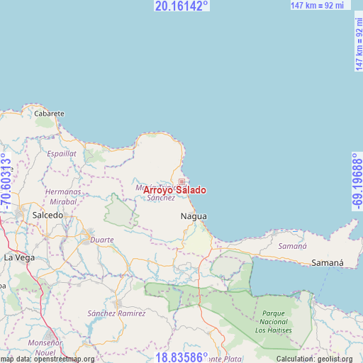
Arroyo Salado GPS coordinates[2]
19° 30' 0" North, 69° 54' 0" West
| Map corner | latitude | longitude |
|---|---|---|
| Upper-left | 20.16142°, | -70.60313° |
| Center: | 19.5°, | -69.9° |
| Lower-right: | 18.83586°, | -69.19688° |
| Map W x H: | 147.4×147.4 km | = 91.6×91.6mi |
| max Lat: | 19.89131° ⇑19.4% North |
| Arroyo Salado: | 19.5° |
| min Lat: | ⇓80.6% South 17.80136° |
| min Long | Arroyo Salado | max Long |
| -71.85022° | -69.9° | -68.40431° |
| W 81%⇐ | ⇒19% E |
Elevation
Elevation of Arroyo Salado is 6 m = 20 ft, and this is 160.3 m = 526 ft below average elevation for this country.
| Max E: |
1242 m = 4075 ft | 99.5% |
| Avg. | 166.3 m = 546 ft | |
| Arroyo Salado | 6 m = 20 ft | |
Min E: |
5 m = 16 ft | 0.5% |
See also: Dominican Republic elevation on elevation.city.
Geographical zone
Arroyo Salado is located in North Torrid zone (between Equator and Tropic of Cancer). Distance of this Northern Tropic circle is 437.7 km =272 mi to North.| Distance of | km | miles | from Arroyo Salado |
|---|---|---|---|
| North Pole | 7838.9 | 4870.9 | to North |
| Arctic Circle | 5233 | 3251.6 | to North |
| Tropic Cancer | 437.7 | 272 | to North |
| Equator | 2168.2 | 1347.3 | to South |


Nearby cities:
15 places around Arroyo Salado: (largest is in red/bold)
• Agua Santa del Yuna
40.2 km =25 mi,  164°
164°
• Arenoso
35 km =21.7 mi,  172°
172°
• Cabrera
15.9 km =9.9 mi,  358°
358°
• Castillo
35.1 km =21.8 mi,  202°
202°
• El Factor
20.2 km =12.6 mi,  176°
176°
• Gaspar Hernández
42 km =26.1 mi,  289°
289°
• Hostos
37.7 km =23.4 mi, 199°
• Joba Arriba
39.1 km =24.3 mi,  280°
280°
• La Entrada
6 km =3.7 mi,  352°
352°
• La Peña
37.8 km =23.5 mi,  228°
228°
• Nagua
14.1 km =8.8 mi, 156°
• Pimentel
41.4 km =25.7 mi,  211°
211°
• Río San Juan
24.4 km =15.2 mi,  310°
310°
• Sánchez
42.6 km =26.5 mi,  135°
135°
• Villa Riva
35.5 km =22.1 mi, 182°
Sources, notices
• [Note1] Compared only with cities in Dominican Republic existing in our database
• [Src1] Map data: © OpenStreetMap contributors (CC-BY-SA)
• [Src2] Other city data from geonames.org with taken over terms of usage.
• [Src3] Geographical zone / Annual Mean Temperature by Robert A. Rohde @ Wikipedia
