Souma geodata
Souma (Blida) is a populated place; located in Algeria in Africa/Algiers (GMT+1) time zone. With population of 40,745 people, there are 125 cities with bigger population in this country. Compared to other cities in Algeria, 69.4% of cities are located further ↓South; 62.8% of cities are located further →East and 64.3% of cities have higher elevation than Souma. Note1


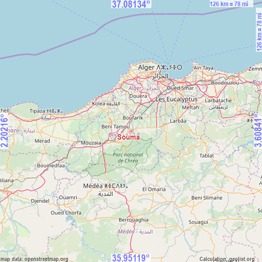
Souma GPS coordinates[2]
36° 31' 5.988" North, 2° 54' 19.008" East
| Map corner | latitude | longitude |
|---|---|---|
| Upper-left | 37.08134°, | 2.20216° |
| Center: | 36.51833°, | 2.90528° |
| Lower-right: | 35.95119°, | 3.60841° |
| Map W x H: | 125.7×125.7 km | = 78.1×78.1mi |
| max Lat: | 36.92917° ⇑30.6% North |
| Souma: | 36.51833° |
| min Lat: | ⇓69.4% South 22.785° |
| min Long | Souma | max Long |
| -8.14743° | 2.90528° | 8.46667° |
| W 37.2%⇐ | ⇒62.8% E |
Elevation
Elevation of Souma is 151 m = 495 ft, and this is 287.5 m = 943 ft below average elevation for this country.
| Max E: |
1392 m = 4567 ft | 64.3% |
| Avg. | 438.5 m = 1439 ft | |
| Souma | 151 m = 495 ft | |
Min E: |
5 m = 16 ft | 35.7% |
See also: Souma elevation on elevation.city.
Geographical zone
Souma is located in North temperate zone (between Tropic of Cancer and the Arctic Circle). Distance of this Northern Tropic circle is 1454.5 km =903.8 mi to South.| Distance of | km | miles | from Souma |
|---|---|---|---|
| North Pole | 5946.6 | 3695 | to North |
| Arctic Circle | 3340.7 | 2075.8 | to North |
| Tropic Cancer | 1454.5 | 903.8 | to South |
| Equator | 4060.5 | 2523.1 | to South |


Nearby cities:
15 places around Souma: (largest is in red/bold)
• Beni Mered
4 km =2.5 mi,  278°
278°
• Blida
8.8 km =5.5 mi,  232°
232°
• Boufarik
6.2 km =3.9 mi,  5°
5°
• Bougara
15.9 km =9.9 mi,  80°
80°
• Bouinan
7.9 km =4.9 mi, 79°
• Boû Arfa
10.2 km =6.3 mi, 232°
• Chebli
11.4 km =7.1 mi,  54°
54°
• Chiffa
16.1 km =10 mi,  247°
247°
• Douera
17.2 km =10.7 mi, 11°
• Kolea
18.1 km =11.2 mi,  317°
317°
• Larbaâ
22.8 km =14.2 mi, 76°
• Mouzaïa
20.1 km =12.5 mi, 253°
• Oued el Alleug
11.1 km =6.9 mi,  291°
291°
• Sidi Moussa
19 km =11.8 mi,  59°
59°
• Zeralda
22.2 km =13.8 mi,  345°
345°
Sources, notices
• [Note1] Compared only with cities in Algeria existing in our database
• [Src1] Map data: © OpenStreetMap contributors (CC-BY-SA)
• [Src2] Other city data from geonames.org with taken over terms of usage.
• [Src3] Geographical zone / Annual Mean Temperature by Robert A. Rohde @ Wikipedia
