Kolea geodata
Kolea (Tipaza) is a populated place; located in Algeria in Africa/Algiers (GMT+1) time zone. With population of 31,816 people, there are 164 cities with bigger population in this country. Compared to other cities in Algeria, 79.8% of cities are located further ↓South; 65.9% of cities are located further →East and 67.1% of cities have higher elevation than Kolea. Note1


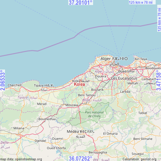
Kolea GPS coordinates[2]
36° 38' 19.968" North, 2° 46' 6.42" East
| Map corner | latitude | longitude |
|---|---|---|
| Upper-left | 37.20101°, | 2.06533° |
| Center: | 36.63888°, | 2.76845° |
| Lower-right: | 36.07262°, | 3.47158° |
| Map W x H: | 125.5×125.5 km | = 78×78mi |
| max Lat: | 36.92917° ⇑20.2% North |
| Kolea: | 36.63888° |
| min Lat: | ⇓79.8% South 22.785° |
| min Long | Kolea | max Long |
| -8.14743° | 2.76845° | 8.46667° |
| W 34.1%⇐ | ⇒65.9% E |
Elevation
Elevation of Kolea is 137 m = 449 ft, and this is 301.5 m = 989 ft below average elevation for this country.
| Max E: |
1392 m = 4567 ft | 67.1% |
| Avg. | 438.5 m = 1439 ft | |
| Kolea | 137 m = 449 ft | |
Min E: |
5 m = 16 ft | 32.9% |
See also: Algeria elevation on elevation.city.
Geographical zone
Kolea is located in North temperate zone (between Tropic of Cancer and the Arctic Circle). Distance of this Northern Tropic circle is 1467.9 km =912.1 mi to South.| Distance of | km | miles | from Kolea |
|---|---|---|---|
| North Pole | 5933.2 | 3686.7 | to North |
| Arctic Circle | 3327.3 | 2067.5 | to North |
| Tropic Cancer | 1467.9 | 912.1 | to South |
| Equator | 4073.9 | 2531.4 | to South |


Nearby cities:
15 places around Kolea: (largest is in red/bold)
• Beni Mered
15.2 km =9.4 mi,  147°
147°
• Blida
19.5 km =12.1 mi,  164°
164°
• Bou Ismaïl
7 km =4.3 mi,  273°
273°
• Boufarik
14.7 km =9.1 mi,  119°
119°
• Boû Arfa
20 km =12.4 mi,  168°
168°
• Chebli
22.6 km =14 mi,  107°
107°
• Cheraga
22.2 km =13.8 mi,  49°
49°
• Chiffa
19.7 km =12.2 mi,  187°
187°
• Douera
16.1 km =10 mi,  77°
77°
• El Affroun
22.7 km =14.1 mi,  214°
214°
• Mouzaïa
20.4 km =12.7 mi,  200°
200°
• Oued el Alleug
9.5 km =5.9 mi, 168°
• Souma
18.1 km =11.2 mi,  137°
137°
• Zeralda
10.4 km =6.5 mi,  39°
39°
• ’Aïn Benian
22.8 km =14.2 mi, 36°
Sources, notices
• [Note1] Compared only with cities in Algeria existing in our database
• [Src1] Map data: © OpenStreetMap contributors (CC-BY-SA)
• [Src2] Other city data from geonames.org with taken over terms of usage.
• [Src3] Geographical zone / Annual Mean Temperature by Robert A. Rohde @ Wikipedia
