Douera geodata
Douera (Tipaza) is a populated place; located in Algeria in Africa/Algiers (GMT+1) time zone. With population of 26,926 people, there are 190 cities with bigger population in this country. Compared to other cities in Algeria, 82.9% of cities are located further ↓South; 60.9% of cities are located further →East and 59.7% of cities have higher elevation than Douera. Note1


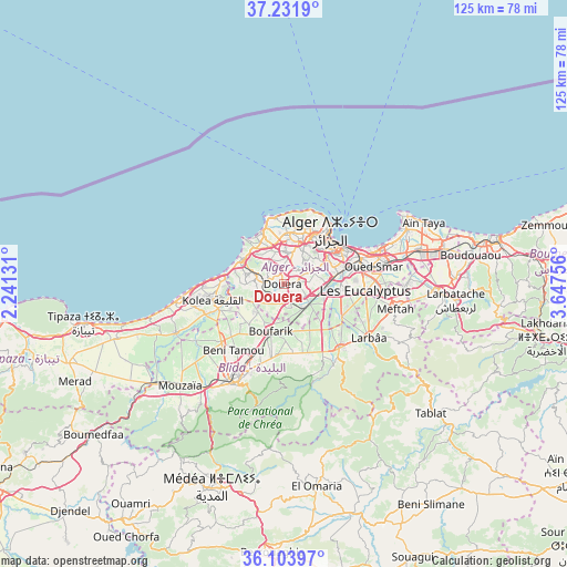
Douera GPS coordinates[2]
36° 40' 12" North, 2° 56' 39.984" East
| Map corner | latitude | longitude |
|---|---|---|
| Upper-left | 37.2319°, | 2.24131° |
| Center: | 36.67°, | 2.94444° |
| Lower-right: | 36.10397°, | 3.64756° |
| Map W x H: | 125.4×125.4 km | = 77.9×77.9mi |
| max Lat: | 36.92917° ⇑17.1% North |
| Douera: | 36.67° |
| min Lat: | ⇓82.9% South 22.785° |
| min Long | Douera | max Long |
| -8.14743° | 2.94444° | 8.46667° |
| W 39.1%⇐ | ⇒60.9% E |
Elevation
Elevation of Douera is 178 m = 584 ft, and this is 260.5 m = 855 ft below average elevation for this country.
| Max E: |
1392 m = 4567 ft | 59.7% |
| Avg. | 438.5 m = 1439 ft | |
| Douera | 178 m = 584 ft | |
Min E: |
5 m = 16 ft | 40.3% |
See also: Algeria elevation on elevation.city.
Geographical zone
Douera is located in North temperate zone (between Tropic of Cancer and the Arctic Circle). Distance of this Northern Tropic circle is 1471.4 km =914.3 mi to South.| Distance of | km | miles | from Douera |
|---|---|---|---|
| North Pole | 5929.7 | 3684.5 | to North |
| Arctic Circle | 3323.9 | 2065.4 | to North |
| Tropic Cancer | 1471.4 | 914.3 | to South |
| Equator | 4077.3 | 2533.5 | to South |


Nearby cities:
15 places around Douera: (largest is in red/bold)
• Algiers
14.5 km =9 mi,  61°
61°
• Baraki
13.5 km =8.4 mi,  91°
91°
• Beni Mered
17.9 km =11.1 mi,  204°
204°
• Birkhadem
10.7 km =6.6 mi, 62°
• Boufarik
11 km =6.8 mi, 195°
• Bougara
18.8 km =11.7 mi,  139°
139°
• Bouinan
16 km =9.9 mi,  164°
164°
• Chebli
11.8 km =7.3 mi,  150°
150°
• Cheraga
10.9 km =6.8 mi,  6°
6°
• Kolea
16.1 km =10 mi,  257°
257°
• Saoula
8.1 km =5 mi, 61°
• Sidi Moussa
14.6 km =9.1 mi,  118°
118°
• Souma
17.2 km =10.7 mi,  191°
191°
• Zeralda
10.2 km =6.3 mi,  297°
297°
• ’Aïn Benian
14.9 km =9.3 mi,  352°
352°
Sources, notices
• [Note1] Compared only with cities in Algeria existing in our database
• [Src1] Map data: © OpenStreetMap contributors (CC-BY-SA)
• [Src2] Other city data from geonames.org with taken over terms of usage.
• [Src3] Geographical zone / Annual Mean Temperature by Robert A. Rohde @ Wikipedia
