Bouinan geodata
Bouinan (Blida) is a populated place; located in Algeria in Africa/Algiers (GMT+1) time zone. With population of 30,271 people, there are 172 cities with bigger population in this country. Compared to other cities in Algeria, 70.5% of cities are located further ↓South; 60.1% of cities are located further →East and 77.1% of cities have higher elevation than Bouinan. Note1


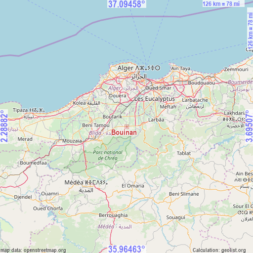
Bouinan GPS coordinates[2]
36° 31' 54.012" North, 2° 59' 30.984" East
| Map corner | latitude | longitude |
|---|---|---|
| Upper-left | 37.09458°, | 2.28882° |
| Center: | 36.53167°, | 2.99194° |
| Lower-right: | 35.96463°, | 3.69507° |
| Map W x H: | 125.6×125.6 km | = 78×78mi |
| max Lat: | 36.92917° ⇑29.5% North |
| Bouinan: | 36.53167° |
| min Lat: | ⇓70.5% South 22.785° |
| min Long | Bouinan | max Long |
| -8.14743° | 2.99194° | 8.46667° |
| W 39.9%⇐ | ⇒60.1% E |
Elevation
Elevation of Bouinan is 92 m = 302 ft, and this is 346.5 m = 1137 ft below average elevation for this country.
| Max E: |
1392 m = 4567 ft | 77.1% |
| Avg. | 438.5 m = 1439 ft | |
| Bouinan | 92 m = 302 ft | |
Min E: |
5 m = 16 ft | 22.9% |
See also: Algeria elevation on elevation.city.
Geographical zone
Bouinan is located in North temperate zone (between Tropic of Cancer and the Arctic Circle). Distance of this Northern Tropic circle is 1456 km =904.7 mi to South.| Distance of | km | miles | from Bouinan |
|---|---|---|---|
| North Pole | 5945.1 | 3694.1 | to North |
| Arctic Circle | 3339.2 | 2074.9 | to North |
| Tropic Cancer | 1456 | 904.7 | to South |
| Equator | 4061.9 | 2523.9 | to South |


Nearby cities:
15 places around Bouinan: (largest is in red/bold)
• Baraki
17.6 km =10.9 mi,  31°
31°
• Beni Mered
11.7 km =7.3 mi,  265°
265°
• Birkhadem
21 km =13 mi,  14°
14°
• Blida
16.2 km =10.1 mi,  244°
244°
• Boufarik
8.5 km =5.3 mi,  303°
303°
• Bougara
8 km =5 mi,  81°
81°
• Boû Arfa
17.6 km =10.9 mi, 244°
• Chebli
5.3 km =3.3 mi,  16°
16°
• Douera
16 km =9.9 mi,  344°
344°
• Larbaâ
15 km =9.3 mi, 75°
• Meftah
22.8 km =14.2 mi,  64°
64°
• Oued el Alleug
18.2 km =11.3 mi,  278°
278°
• Saoula
19.4 km =12.1 mi, 8°
• Sidi Moussa
11.9 km =7.4 mi,  45°
45°
• Souma
7.9 km =4.9 mi,  259°
259°
Sources, notices
• [Note1] Compared only with cities in Algeria existing in our database
• [Src1] Map data: © OpenStreetMap contributors (CC-BY-SA)
• [Src2] Other city data from geonames.org with taken over terms of usage.
• [Src3] Geographical zone / Annual Mean Temperature by Robert A. Rohde @ Wikipedia
