Sidi Moussa geodata
Sidi Moussa (Blida) is a populated place; located in Algeria in Africa/Algiers (GMT+1) time zone. With population of 57,928 people, there are 82 cities with bigger population in this country. Compared to other cities in Algeria, 77.5% of cities are located further ↓South; 57.8% of cities are located further →East and 88.4% of cities have higher elevation than Sidi Moussa. Note1


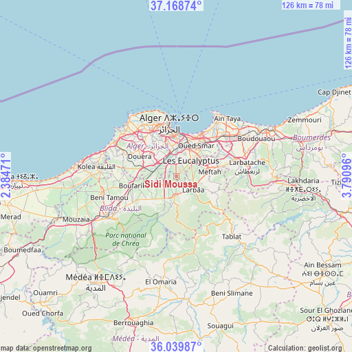
Sidi Moussa GPS coordinates[2]
36° 36' 22.932" North, 3° 5' 16.188" East
| Map corner | latitude | longitude |
|---|---|---|
| Upper-left | 37.16874°, | 2.38471° |
| Center: | 36.60637°, | 3.08783° |
| Lower-right: | 36.03987°, | 3.79096° |
| Map W x H: | 125.5×125.5 km | = 78×78mi |
| max Lat: | 36.92917° ⇑22.5% North |
| Sidi Moussa: | 36.60637° |
| min Lat: | ⇓77.5% South 22.785° |
| min Long | Sidi Moussa | max Long |
| -8.14743° | 3.08783° | 8.46667° |
| W 42.2%⇐ | ⇒57.8% E |
Elevation
Elevation of Sidi Moussa is 46 m = 151 ft, and this is 392.5 m = 1288 ft below average elevation for this country.
| Max E: |
1392 m = 4567 ft | 88.4% |
| Avg. | 438.5 m = 1439 ft | |
| Sidi Moussa | 46 m = 151 ft | |
Min E: |
5 m = 16 ft | 11.6% |
See also: Sidi Moussa elevation on elevation.city.
Geographical zone
Sidi Moussa is located in North temperate zone (between Tropic of Cancer and the Arctic Circle). Distance of this Northern Tropic circle is 1464.3 km =909.9 mi to South.| Distance of | km | miles | from Sidi Moussa |
|---|---|---|---|
| North Pole | 5936.8 | 3689 | to North |
| Arctic Circle | 3330.9 | 2069.7 | to North |
| Tropic Cancer | 1464.3 | 909.9 | to South |
| Equator | 4070.2 | 2529.1 | to South |


Nearby cities:
15 places around Sidi Moussa: (largest is in red/bold)
• Algiers
14 km =8.7 mi,  359°
359°
• Bab Ezzouar
15.8 km =9.8 mi,  32°
32°
• Baraki
6.7 km =4.2 mi,  6°
6°
• Birkhadem
12.5 km =7.8 mi,  344°
344°
• Bordj el Kiffan
18.4 km =11.4 mi, 30°
• Boufarik
16.1 km =10 mi,  257°
257°
• Bougara
7.2 km =4.5 mi,  184°
184°
• Bouinan
11.9 km =7.4 mi,  225°
225°
• Chebli
7.7 km =4.8 mi,  245°
245°
• Dar el Beïda
16.3 km =10.1 mi,  43°
43°
• Douera
14.6 km =9.1 mi,  298°
298°
• Larbaâ
7.5 km =4.7 mi,  127°
127°
• Meftah
12.1 km =7.5 mi,  82°
82°
• Saoula
12.3 km =7.6 mi,  332°
332°
• Souma
19 km =11.8 mi,  239°
239°
Sources, notices
• [Note1] Compared only with cities in Algeria existing in our database
• [Src1] Map data: © OpenStreetMap contributors (CC-BY-SA)
• [Src2] Other city data from geonames.org with taken over terms of usage.
• [Src3] Geographical zone / Annual Mean Temperature by Robert A. Rohde @ Wikipedia
