Chebli geodata
Chebli (Blida) is a populated place; located in Algeria in Africa/Algiers (GMT+1) time zone. With population of 19,901 people, there are 229 cities with bigger population in this country. Compared to other cities in Algeria, 75.6% of cities are located further ↓South; 59.7% of cities are located further →East and 85.3% of cities have higher elevation than Chebli. Note1


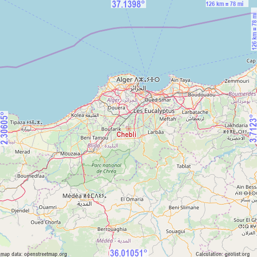
Chebli GPS coordinates[2]
36° 34' 37.992" North, 3° 0' 33.012" East
| Map corner | latitude | longitude |
|---|---|---|
| Upper-left | 37.1398°, | 2.30605° |
| Center: | 36.57722°, | 3.00917° |
| Lower-right: | 36.01051°, | 3.7123° |
| Map W x H: | 125.6×125.6 km | = 78×78mi |
| max Lat: | 36.92917° ⇑24.4% North |
| Chebli: | 36.57722° |
| min Lat: | ⇓75.6% South 22.785° |
| min Long | Chebli | max Long |
| -8.14743° | 3.00917° | 8.46667° |
| W 40.3%⇐ | ⇒59.7% E |
Elevation
Elevation of Chebli is 56 m = 184 ft, and this is 382.5 m = 1255 ft below average elevation for this country.
| Max E: |
1392 m = 4567 ft | 85.3% |
| Avg. | 438.5 m = 1439 ft | |
| Chebli | 56 m = 184 ft | |
Min E: |
5 m = 16 ft | 14.7% |
See also: Algeria elevation on elevation.city.
Geographical zone
Chebli is located in North temperate zone (between Tropic of Cancer and the Arctic Circle). Distance of this Northern Tropic circle is 1461.1 km =907.9 mi to South.| Distance of | km | miles | from Chebli |
|---|---|---|---|
| North Pole | 5940.1 | 3691 | to North |
| Arctic Circle | 3334.2 | 2071.8 | to North |
| Tropic Cancer | 1461.1 | 907.9 | to South |
| Equator | 4067 | 2527.1 | to South |


Nearby cities:
15 places around Chebli: (largest is in red/bold)
• Algiers
18.6 km =11.6 mi,  22°
22°
• Baraki
12.6 km =7.8 mi,  37°
37°
• Beni Mered
14.5 km =9 mi,  245°
245°
• Birkhadem
15.7 km =9.8 mi,  13°
13°
• Blida
20.1 km =12.5 mi,  233°
233°
• Boufarik
8.7 km =5.4 mi,  267°
267°
• Bougara
7.5 km =4.7 mi,  121°
121°
• Bouinan
5.3 km =3.3 mi,  196°
196°
• Douera
11.8 km =7.3 mi,  330°
330°
• Larbaâ
13 km =8.1 mi,  96°
96°
• Meftah
19.6 km =12.2 mi,  75°
75°
• Oued el Alleug
19.7 km =12.2 mi,  262°
262°
• Saoula
14.2 km =8.8 mi, 5°
• Sidi Moussa
7.7 km =4.8 mi,  65°
65°
• Souma
11.4 km =7.1 mi, 234°
Sources, notices
• [Note1] Compared only with cities in Algeria existing in our database
• [Src1] Map data: © OpenStreetMap contributors (CC-BY-SA)
• [Src2] Other city data from geonames.org with taken over terms of usage.
• [Src3] Geographical zone / Annual Mean Temperature by Robert A. Rohde @ Wikipedia
