Zeralda geodata
Zeralda (Tipaza) is a populated place; located in Algeria in Africa/Algiers (GMT+1) time zone. With population of 17,563 people, there are 239 cities with bigger population in this country. Compared to other cities in Algeria, 86% of cities are located further ↓South; 64% of cities are located further →East and 92.2% of cities have higher elevation than Zeralda. Note1


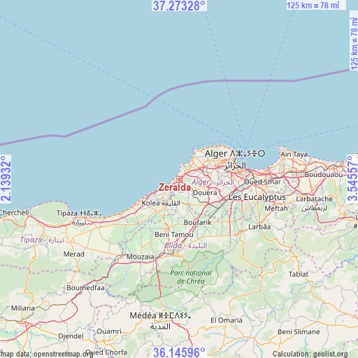
Zeralda GPS coordinates[2]
36° 42' 42.084" North, 2° 50' 32.784" East
| Map corner | latitude | longitude |
|---|---|---|
| Upper-left | 37.27328°, | 2.13932° |
| Center: | 36.71169°, | 2.84244° |
| Lower-right: | 36.14596°, | 3.54557° |
| Map W x H: | 125.3×125.3 km | = 77.9×77.9mi |
| max Lat: | 36.92917° ⇑14% North |
| Zeralda: | 36.71169° |
| min Lat: | ⇓86% South 22.785° |
| min Long | Zeralda | max Long |
| -8.14743° | 2.84244° | 8.46667° |
| W 36%⇐ | ⇒64% E |
Elevation
Elevation of Zeralda is 30 m = 98 ft, and this is 408.5 m = 1340 ft below average elevation for this country.
| Max E: |
1392 m = 4567 ft | 92.2% |
| Avg. | 438.5 m = 1439 ft | |
| Zeralda | 30 m = 98 ft | |
Min E: |
5 m = 16 ft | 7.8% |
See also: Algeria elevation on elevation.city.
Geographical zone
Zeralda is located in North temperate zone (between Tropic of Cancer and the Arctic Circle). Distance of this Northern Tropic circle is 1476 km =917.1 mi to South.| Distance of | km | miles | from Zeralda |
|---|---|---|---|
| North Pole | 5925.1 | 3681.7 | to North |
| Arctic Circle | 3319.2 | 2062.5 | to North |
| Tropic Cancer | 1476 | 917.1 | to South |
| Equator | 4082 | 2536.4 | to South |


Nearby cities:
15 places around Zeralda: (largest is in red/bold)
• Algiers
22 km =13.7 mi,  84°
84°
• Baraki
23.2 km =14.4 mi,  102°
102°
• Beni Mered
20.9 km =13 mi,  175°
175°
• Birkhadem
18.5 km =11.5 mi,  88°
88°
• Bou Ismaïl
15.6 km =9.7 mi,  240°
240°
• Boufarik
16.5 km =10.3 mi,  157°
157°
• Bouinan
24.1 km =15 mi,  146°
146°
• Chebli
21.1 km =13.1 mi,  135°
135°
• Cheraga
12.1 km =7.5 mi,  59°
59°
• Douera
10.2 km =6.3 mi,  117°
117°
• Kolea
10.4 km =6.5 mi,  219°
219°
• Oued el Alleug
18 km =11.2 mi,  194°
194°
• Saoula
16.3 km =10.1 mi, 92°
• Souma
22.2 km =13.8 mi,  165°
165°
• ’Aïn Benian
12.4 km =7.7 mi,  34°
34°
Sources, notices
• [Note1] Compared only with cities in Algeria existing in our database
• [Src1] Map data: © OpenStreetMap contributors (CC-BY-SA)
• [Src2] Other city data from geonames.org with taken over terms of usage.
• [Src3] Geographical zone / Annual Mean Temperature by Robert A. Rohde @ Wikipedia
