Relizane geodata
Relizane is a seat of a first-order administrative division; located in Algeria in Africa/Algiers (GMT+1) time zone. With population of 130,094 people, there are 28 cities with bigger population in this country. Compared to other cities in Algeria, 58.9% of cities are located further ↑North; 83.7% of cities are located further →East and 74.4% of cities have higher elevation than Relizane. Note1


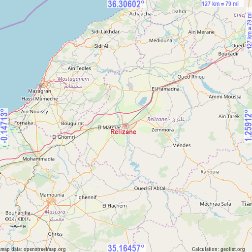
Relizane GPS coordinates[2]
35° 44' 14.424" North, 0° 33' 21.564" East
| Map corner | latitude | longitude |
|---|---|---|
| Upper-left | 36.30602°, | -0.14713° |
| Center: | 35.73734°, | 0.55599° |
| Lower-right: | 35.16457°, | 1.25912° |
| Map W x H: | 126.9×126.9 km | = 78.9×78.9mi |
| max Lat: | 36.92917° ⇑58.9% North |
| Relizane: | 35.73734° |
| min Lat: | ⇓41.1% South 22.785° |
| min Long | Relizane | max Long |
| -8.14743° | 0.55599° | 8.46667° |
| W 16.3%⇐ | ⇒83.7% E |
Elevation
Elevation of Relizane is 98 m = 322 ft, and this is 340.5 m = 1117 ft below average elevation for this country.
| Max E: |
1392 m = 4567 ft | 74.4% |
| Avg. | 438.5 m = 1439 ft | |
| Relizane | 98 m = 322 ft | |
Min E: |
5 m = 16 ft | 25.6% |
See also: Relizane elevation on elevation.city.
Geographical zone
Relizane is located in North temperate zone (between Tropic of Cancer and the Arctic Circle). Distance of this Northern Tropic circle is 1367.7 km =849.8 mi to South.| Distance of | km | miles | from Relizane |
|---|---|---|---|
| North Pole | 6033.4 | 3749 | to North |
| Arctic Circle | 3427.6 | 2129.8 | to North |
| Tropic Cancer | 1367.7 | 849.8 | to South |
| Equator | 3973.6 | 2469.1 | to South |


Nearby cities:
15 places around Relizane: (largest is in red/bold)
• Ammi Moussa
52.1 km =32.4 mi,  73°
73°
• Bou Hanifia el Hamamat
72.2 km =44.9 mi,  229°
229°
• Boukadir
63 km =39.1 mi,  54°
54°
• Djidiouia
32.6 km =20.3 mi, 48°
• Mascara
53.4 km =33.2 mi,  224°
224°
• Mazouna
52.8 km =32.8 mi,  35°
35°
• Mostaganem
47.3 km =29.4 mi,  297°
297°
• Oued Rhiou
41.1 km =25.5 mi, 52°
• Oued Sly
70.7 km =43.9 mi,  55°
55°
• Oued el Abtal
33.5 km =20.8 mi,  159°
159°
• Rouachdia
16.1 km =10 mi,  101°
101°
• Sig
71.6 km =44.5 mi,  251°
251°
• Smala
18.1 km =11.2 mi, 97°
• Zemoura
18 km =11.2 mi, 95°
• ’Aïn Merane
60.2 km =37.4 mi, 38°
Sources, notices
• [Note1] Compared only with cities in Algeria existing in our database
• [Src1] Map data: © OpenStreetMap contributors (CC-BY-SA)
• [Src2] Other city data from geonames.org with taken over terms of usage.
• [Src3] Geographical zone / Annual Mean Temperature by Robert A. Rohde @ Wikipedia
