Mostaganem geodata
Mostaganem is a seat of a first-order administrative division; located in Algeria in Africa/Algiers (GMT+1) time zone. With population of 130,000 people, there are 29 cities with bigger population in this country. Compared to other cities in Algeria, 52.7% of cities are located further ↑North; 86.4% of cities are located further →East and 72.9% of cities have higher elevation than Mostaganem. Note1


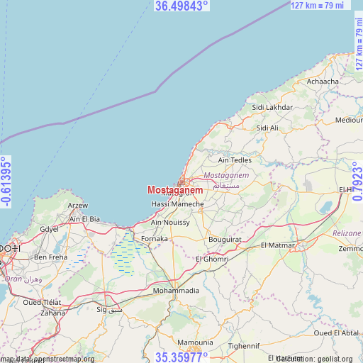
Mostaganem GPS coordinates[2]
35° 55' 52.14" North, 0° 5' 21.048" East
| Map corner | latitude | longitude |
|---|---|---|
| Upper-left | 36.49843°, | -0.61395° |
| Center: | 35.93115°, | 0.08918° |
| Lower-right: | 35.35977°, | 0.7923° |
| Map W x H: | 126.6×126.6 km | = 78.7×78.7mi |
| max Lat: | 36.92917° ⇑52.7% North |
| Mostaganem: | 35.93115° |
| min Lat: | ⇓47.3% South 22.785° |
| min Long | Mostaganem | max Long |
| -8.14743° | 0.08918° | 8.46667° |
| W 13.6%⇐ | ⇒86.4% E |
Elevation
Elevation of Mostaganem is 102 m = 335 ft, and this is 336.5 m = 1104 ft below average elevation for this country.
| Max E: |
1392 m = 4567 ft | 72.9% |
| Avg. | 438.5 m = 1439 ft | |
| Mostaganem | 102 m = 335 ft | |
Min E: |
5 m = 16 ft | 27.1% |
See also: Mostaganem elevation on elevation.city.
Geographical zone
Mostaganem is located in North temperate zone (between Tropic of Cancer and the Arctic Circle). Distance of this Northern Tropic circle is 1389.3 km =863.3 mi to South.| Distance of | km | miles | from Mostaganem |
|---|---|---|---|
| North Pole | 6011.9 | 3735.6 | to North |
| Arctic Circle | 3406 | 2116.4 | to North |
| Tropic Cancer | 1389.3 | 863.3 | to South |
| Equator | 3995.2 | 2482.5 | to South |


Nearby cities:
15 places around Mostaganem: (largest is in red/bold)
• Aïn el Bya
38 km =23.6 mi,  248°
248°
• Bir el Djir
61.8 km =38.4 mi, 247°
• Bou Hanifia el Hamamat
69.7 km =43.3 mi,  190°
190°
• Djidiouia
66.6 km =41.4 mi,  90°
90°
• Es Senia
71.6 km =44.5 mi,  243°
243°
• Mascara
59.6 km =37 mi,  175°
175°
• Mers el Kebir
75.3 km =46.8 mi, 252°
• Oran
70.3 km =43.7 mi, 248°
• Oued Rhiou
74.8 km =46.5 mi, 87°
• Relizane
47.3 km =29.4 mi,  117°
117°
• Rouachdia
62.9 km =39.1 mi,  113°
113°
• Sidi ech Chahmi
62.9 km =39.1 mi, 241°
• Sig
51.6 km =32.1 mi,  209°
209°
• Smala
64.5 km =40.1 mi, 111°
• Zemoura
64.4 km =40 mi, 111°
Sources, notices
• [Note1] Compared only with cities in Algeria existing in our database
• [Src1] Map data: © OpenStreetMap contributors (CC-BY-SA)
• [Src2] Other city data from geonames.org with taken over terms of usage.
• [Src3] Geographical zone / Annual Mean Temperature by Robert A. Rohde @ Wikipedia
