Rouachdia geodata
Rouachdia (Relizane) is a populated place; located in Algeria in Africa/Algiers (GMT+1) time zone. With population of 1,000 people, there are 256 cities with bigger population in this country. Compared to other cities in Algeria, 60.9% of cities are located further ↑North; 82.9% of cities are located further →East and 54.3% of cities have lower elevation than Rouachdia. Note1


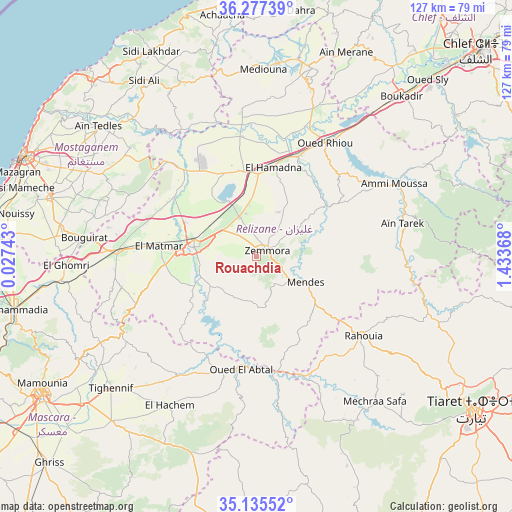
Rouachdia GPS coordinates[2]
35° 42' 30.6" North, 0° 43' 49.98" East
| Map corner | latitude | longitude |
|---|---|---|
| Upper-left | 36.27739°, | 0.02743° |
| Center: | 35.7085°, | 0.73055° |
| Lower-right: | 35.13552°, | 1.43368° |
| Map W x H: | 127×127 km | = 78.9×78.9mi |
| max Lat: | 36.92917° ⇑60.9% North |
| Rouachdia: | 35.7085° |
| min Lat: | ⇓39.1% South 22.785° |
| min Long | Rouachdia | max Long |
| -8.14743° | 0.73055° | 8.46667° |
| W 17.1%⇐ | ⇒82.9% E |
Elevation
Elevation of Rouachdia is 358 m = 1175 ft, and this is 80.5 m = 264 ft below average elevation for this country.
| Max E: |
1392 m = 4567 ft | 45.7% |
| Avg. | 438.5 m = 1439 ft | |
| Rouachdia | 358 m = 1175 ft | |
Min E: |
5 m = 16 ft | 54.3% |
See also: Algeria elevation on elevation.city.
Geographical zone
Rouachdia is located in North temperate zone (between Tropic of Cancer and the Arctic Circle). Distance of this Northern Tropic circle is 1364.5 km =847.9 mi to South.| Distance of | km | miles | from Rouachdia |
|---|---|---|---|
| North Pole | 6036.6 | 3751 | to North |
| Arctic Circle | 3430.8 | 2131.8 | to North |
| Tropic Cancer | 1364.5 | 847.9 | to South |
| Equator | 3970.4 | 2467.1 | to South |


Nearby cities:
15 places around Rouachdia: (largest is in red/bold)
• Ammi Moussa
38.7 km =24 mi,  62°
62°
• Boukadir
53.4 km =33.2 mi,  41°
41°
• Djidiouia
26.2 km =16.3 mi,  19°
19°
• Ech Chettia
71.9 km =44.7 mi, 41°
• Mascara
63.7 km =39.6 mi,  237°
237°
• Mazouna
48.4 km =30.1 mi, 18°
• Mostaganem
62.9 km =39.1 mi,  293°
293°
• Oued Rhiou
32.8 km =20.4 mi,  31°
31°
• Oued Sly
60.8 km =37.8 mi, 44°
• Oued el Abtal
28.3 km =17.6 mi,  187°
187°
• Relizane
16.1 km =10 mi,  281°
281°
• Smala
2.3 km =1.4 mi,  67°
67°
• Tiaret
65 km =40.4 mi,  125°
125°
• Zemoura
2.7 km =1.7 mi,  54°
54°
• ’Aïn Merane
54.9 km =34.1 mi, 23°
Sources, notices
• [Note1] Compared only with cities in Algeria existing in our database
• [Src1] Map data: © OpenStreetMap contributors (CC-BY-SA)
• [Src2] Other city data from geonames.org with taken over terms of usage.
• [Src3] Geographical zone / Annual Mean Temperature by Robert A. Rohde @ Wikipedia
