Berrouaghia geodata
Berrouaghia (Medea) is a populated place; located in Algeria in Africa/Algiers (GMT+1) time zone. With population of 80,573 people, there are 49 cities with bigger population in this country. Compared to other cities in Algeria, 52.7% of cities are located further ↓South; 62% of cities are located further →East and 86.8% of cities have lower elevation than Berrouaghia. Note1


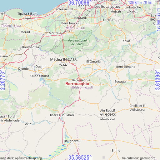
Berrouaghia GPS coordinates[2]
36° 8' 6.576" North, 2° 54' 39.06" East
| Map corner | latitude | longitude |
|---|---|---|
| Upper-left | 36.70096°, | 2.20773° |
| Center: | 36.13516°, | 2.91085° |
| Lower-right: | 35.56525°, | 3.61398° |
| Map W x H: | 126.3×126.3 km | = 78.5×78.5mi |
| max Lat: | 36.92917° ⇑47.3% North |
| Berrouaghia: | 36.13516° |
| min Lat: | ⇓52.7% South 22.785° |
| min Long | Berrouaghia | max Long |
| -8.14743° | 2.91085° | 8.46667° |
| W 38%⇐ | ⇒62% E |
Elevation
Elevation of Berrouaghia is 946 m = 3104 ft, and this is 507.5 m = 1665 ft above average elevation for this country.
| Max E: |
1392 m = 4567 ft | 13.2% |
| Berrouaghia | 946 m 3104 ft | |
| Avg. | 438.5 m = 1439 ft | |
Min E: |
5 m = 16 ft | 86.8% |
See also: Berrouaghia elevation on elevation.city.
Geographical zone
Berrouaghia is located in North temperate zone (between Tropic of Cancer and the Arctic Circle). Distance of this Northern Tropic circle is 1411.9 km =877.3 mi to South.| Distance of | km | miles | from Berrouaghia |
|---|---|---|---|
| North Pole | 5989.2 | 3721.5 | to North |
| Arctic Circle | 3383.3 | 2102.3 | to North |
| Tropic Cancer | 1411.9 | 877.3 | to South |
| Equator | 4017.9 | 2496.6 | to South |


Nearby cities:
15 places around Berrouaghia: (largest is in red/bold)
• Beni Mered
43.4 km =27 mi,  354°
354°
• Blida
38 km =23.6 mi, 348°
• Boufarik
48.8 km =30.3 mi,  0°
0°
• Bougara
47.7 km =29.6 mi,  18°
18°
• Bouinan
44.7 km =27.8 mi,  9°
9°
• Boû Arfa
37.5 km =23.3 mi, 346°
• Chebli
49.9 km =31 mi, 10°
• Chiffa
39.6 km =24.6 mi,  337°
337°
• El Affroun
45.2 km =28.1 mi,  325°
325°
• Ksar el Boukhari
31 km =19.3 mi,  207°
207°
• Mouzaïa
41.9 km =26 mi, 331°
• Médéa
20.1 km =12.5 mi,  315°
315°
• Oued el Alleug
47.9 km =29.8 mi, 346°
• Souma
42.6 km =26.5 mi,  359°
359°
• ’Aïn Boucif
35.1 km =21.8 mi,  140°
140°
Sources, notices
• [Note1] Compared only with cities in Algeria existing in our database
• [Src1] Map data: © OpenStreetMap contributors (CC-BY-SA)
• [Src2] Other city data from geonames.org with taken over terms of usage.
• [Src3] Geographical zone / Annual Mean Temperature by Robert A. Rohde @ Wikipedia
