’Aïn Boucif geodata
’Aïn Boucif (Medea) is a populated place; located in Algeria in Africa/Algiers (GMT+1) time zone. With population of 11,989 people, there are 248 cities with bigger population in this country. Compared to other cities in Algeria, 54.3% of cities are located further ↑North; 56.6% of cities are located further →East and 95.7% of cities have lower elevation than ’Aïn Boucif. Note1


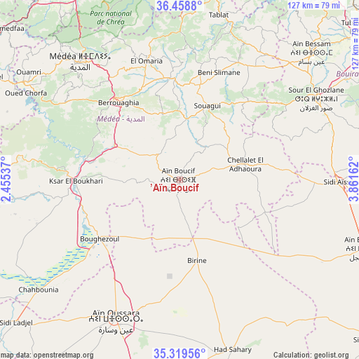
’Aïn Boucif GPS coordinates[2]
35° 53' 28.428" North, 3° 9' 30.6" East
| Map corner | latitude | longitude |
|---|---|---|
| Upper-left | 36.4588°, | 2.45537° |
| Center: | 35.89123°, | 3.1585° |
| Lower-right: | 35.31956°, | 3.86162° |
| Map W x H: | 126.7×126.7 km | = 78.7×78.7mi |
| max Lat: | 36.92917° ⇑54.3% North |
| ’Aïn Boucif: | 35.89123° |
| min Lat: | ⇓45.7% South 22.785° |
| min Long | ’Aïn Boucif | max Long |
| -8.14743° | 3.1585° | 8.46667° |
| W 43.4%⇐ | ⇒56.6% E |
Elevation
Elevation of ’Aïn Boucif is 1123 m = 3684 ft, and this is 684.5 m = 2246 ft above average elevation for this country.
| Max E: |
1392 m = 4567 ft | 4.3% |
| ’Aïn Boucif | 1123 m 3684 ft | |
| Avg. | 438.5 m = 1439 ft | |
Min E: |
5 m = 16 ft | 95.7% |
See also: Algeria elevation on elevation.city.
Geographical zone
’Aïn Boucif is located in North temperate zone (between Tropic of Cancer and the Arctic Circle). Distance of this Northern Tropic circle is 1384.8 km =860.5 mi to South.| Distance of | km | miles | from ’Aïn Boucif |
|---|---|---|---|
| North Pole | 6016.3 | 3738.4 | to North |
| Arctic Circle | 3410.4 | 2119.1 | to North |
| Tropic Cancer | 1384.8 | 860.5 | to South |
| Equator | 3990.7 | 2479.7 | to South |


Nearby cities:
15 places around ’Aïn Boucif: (largest is in red/bold)
• Aïn Bessem
64.3 km =40 mi,  45°
45°
• Aïn Oussera
54 km =33.6 mi,  205°
205°
• Berrouaghia
35.1 km =21.8 mi,  320°
320°
• Birine
29.1 km =18.1 mi,  168°
168°
• Blida
70.9 km =44.1 mi,  335°
335°
• Bougara
72.7 km =45.2 mi,  354°
354°
• Bouinan
72.8 km =45.2 mi, 348°
• Boû Arfa
70.7 km =43.9 mi,  334°
334°
• Chiffa
73.9 km =45.9 mi, 329°
• Ksar el Boukhari
36.9 km =22.9 mi,  269°
269°
• Médéa
55.1 km =34.2 mi, 318°
• Sidi Aïssa
55.3 km =34.4 mi,  90°
90°
• Souma
73.3 km =45.5 mi, 341°
• Sour el Ghozlane
55.8 km =34.7 mi,  59°
59°
• ‘Aïn el Hadjel
69.7 km =43.3 mi,  110°
110°
Sources, notices
• [Note1] Compared only with cities in Algeria existing in our database
• [Src1] Map data: © OpenStreetMap contributors (CC-BY-SA)
• [Src2] Other city data from geonames.org with taken over terms of usage.
• [Src3] Geographical zone / Annual Mean Temperature by Robert A. Rohde @ Wikipedia
