Pedernales geodata
Pedernales (Manabí) is a populated place; located in Ecuador in America/Guayaquil (GMT-5) time zone. With population of 5,983 people, there are 102 cities with bigger population in this country. Compared to other cities in Ecuador, 86.8% of cities are located further ↓South; 80.2% of cities are located further →East and 66.1% of cities have higher elevation than Pedernales. Note1


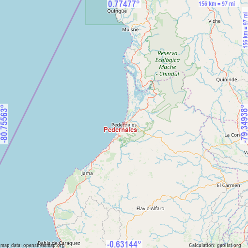
Pedernales GPS coordinates[2]
0° 4' 18.012" North, 80° 3' 9" West
| Map corner | latitude | longitude |
|---|---|---|
| Upper-left | 0.77477°, | -80.75563° |
| Center: | 0.07167°, | -80.0525° |
| Lower-right: | -0.63144°, | -79.34938° |
| Map W x H: | 156.4×156.4 km | = 97.2×97.2mi |
| max Lat: | 1.35251° ⇑13.2% North |
| Pedernales: | 0.07167° |
| min Lat: | ⇓86.8% South -4.38181° |
| min Long | Pedernales | max Long |
| -90.96654° | -80.0525° | -76.89528° |
| W 19.8%⇐ | ⇒80.2% E |
Elevation
Elevation of Pedernales is 32 m = 105 ft, and this is 913.1 m = 2996 ft below average elevation for this country.
| Max E: |
3131 m = 10272 ft | 66.1% |
| Avg. | 945.1 m = 3101 ft | |
| Pedernales | 32 m = 105 ft | |
Min E: |
1 m = 3 ft | 33.9% |
See also: Ecuador elevation on elevation.city.
Geographical zone
Pedernales is located in North Torrid zone (between Equator and Tropic of Cancer). Distance of Equator is 8 km =5 mi to South.| Distance of | km | miles | from Pedernales |
|---|---|---|---|
| North Pole | 9999.1 | 6213.2 | to North |
| Arctic Circle | 7393.2 | 4593.9 | to North |
| Tropic Cancer | 2598 | 1614.3 | to North |
| Equator | 8 | 5 | to South |


Nearby cities:
15 places around Pedernales: (largest is in red/bold)
• Bahía de Caráquez
85.1 km =52.9 mi,  209°
209°
• Calceta
102.8 km =63.9 mi,  186°
186°
• Chone
85.7 km =53.3 mi,  183°
183°
• Cube
71.9 km =44.7 mi,  39°
39°
• Esmeraldas
108.2 km =67.2 mi,  24°
24°
• Junín
112.4 km =69.8 mi, 188°
• Muisne
60.1 km =37.3 mi,  3°
3°
• Portoviejo
133 km =82.6 mi,  199°
199°
• Rocafuerte
119.1 km =74 mi, 201°
• Rosa Zarate
70.3 km =43.7 mi,  66°
66°
• San Vicente
83.5 km =51.9 mi, 208°
• Santo Domingo de los Colorados
104 km =64.6 mi,  110°
110°
• Tosagua
97.6 km =60.6 mi, 191°
• Velasco Ibarra
132.3 km =82.2 mi,  159°
159°
• Wilfrido Loor Moreira
64.3 km =40 mi,  137°
137°
Sources, notices
• [Note1] Compared only with cities in Ecuador existing in our database
• [Src1] Map data: © OpenStreetMap contributors (CC-BY-SA)
• [Src2] Other city data from geonames.org with taken over terms of usage.
• [Src3] Geographical zone / Annual Mean Temperature by Robert A. Rohde @ Wikipedia
