Chone geodata
Chone (Manabí) is a populated place; located in Ecuador in America/Guayaquil (GMT-5) time zone. With population of 44,751 people, there are 24 cities with bigger population in this country. Compared to other cities in Ecuador, 76.9% of cities are located further ↓South; 81.8% of cities are located further →East and 78.5% of cities have higher elevation than Chone. Note1


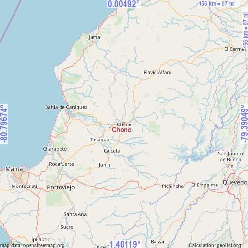
Chone GPS coordinates[2]
0° 41' 53.484" South, 80° 5' 36.996" West
| Map corner | latitude | longitude |
|---|---|---|
| Upper-left | 0.00492°, | -80.79674° |
| Center: | -0.69819°, | -80.09361° |
| Lower-right: | -1.40119°, | -79.39049° |
| Map W x H: | 156.3×156.3 km | = 97.1×97.1mi |
| max Lat: | 1.35251° ⇑23.1% North |
| Chone: | -0.69819° |
| min Lat: | ⇓76.9% South -4.38181° |
| min Long | Chone | max Long |
| -90.96654° | -80.09361° | -76.89528° |
| W 18.2%⇐ | ⇒81.8% E |
Elevation
Elevation of Chone is 16 m = 52 ft, and this is 929.1 m = 3048 ft below average elevation for this country.
| Max E: |
3131 m = 10272 ft | 78.5% |
| Avg. | 945.1 m = 3101 ft | |
| Chone | 16 m = 52 ft | |
Min E: |
1 m = 3 ft | 21.5% |
See also: Chone elevation on elevation.city.
Geographical zone
Chone is located in South Torrid zone (between Equator and Tropic of Capricorn). Distance of Equator is 77.6 km =48.2 mi to North.| Distance of | km | miles | from Chone |
|---|---|---|---|
| Equator | 77.6 | 48.2 | to North |
| Tropic Capricorn | 2528.3 | 1571 | to South |
| Antarctic Circle | 7323.5 | 4550.6 | to South |
| South Pole | 9929.4 | 6169.8 | to South |


Nearby cities:
15 places around Chone: (largest is in red/bold)
• Bahía de Caráquez
38.4 km =23.9 mi,  286°
286°
• Balzar
77.1 km =47.9 mi,  164°
164°
• Calceta
18.2 km =11.3 mi,  205°
205°
• Junín
28.4 km =17.6 mi, 206°
• Manta
74.8 km =46.5 mi,  246°
246°
• Montecristi
73.8 km =45.9 mi,  238°
238°
• Portoviejo
56.4 km =35 mi,  225°
225°
• Quevedo
79.1 km =49.2 mi,  117°
117°
• Rocafuerte
46.8 km =29.1 mi, 237°
• San Vicente
37 km =23 mi, 289°
• Santa Ana
64.5 km =40.1 mi, 208°
• Sucre
74.1 km =46 mi, 209°
• Tosagua
18.5 km =11.5 mi, 237°
• Velasco Ibarra
63.5 km =39.5 mi,  127°
127°
• Wilfrido Loor Moreira
61.6 km =38.3 mi,  51°
51°
Sources, notices
• [Note1] Compared only with cities in Ecuador existing in our database
• [Src1] Map data: © OpenStreetMap contributors (CC-BY-SA)
• [Src2] Other city data from geonames.org with taken over terms of usage.
• [Src3] Geographical zone / Annual Mean Temperature by Robert A. Rohde @ Wikipedia
