Muisne geodata
Muisne (Esmeraldas) is a populated place; located in Ecuador in America/Guayaquil (GMT-5) time zone. With population of 13,393 people, there are 69 cities with bigger population in this country. Compared to other cities in Ecuador, 95% of cities are located further ↓South; 79.3% of cities are located further →East and 99.2% of cities have higher elevation than Muisne. Note1


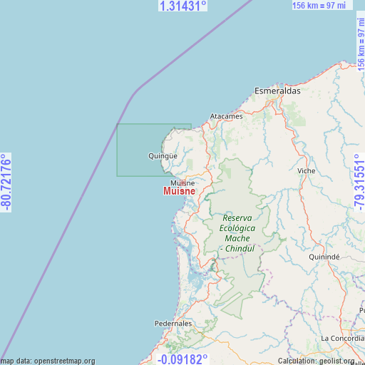
Muisne GPS coordinates[2]
0° 36' 40.644" North, 80° 1' 7.068" West
| Map corner | latitude | longitude |
|---|---|---|
| Upper-left | 1.31431°, | -80.72176° |
| Center: | 0.61129°, | -80.01863° |
| Lower-right: | -0.09182°, | -79.31551° |
| Map W x H: | 156.3×156.4 km | = 97.1×97.2mi |
| max Lat: | 1.35251° ⇑5% North |
| Muisne: | 0.61129° |
| min Lat: | ⇓95% South -4.38181° |
| min Long | Muisne | max Long |
| -90.96654° | -80.01863° | -76.89528° |
| W 20.7%⇐ | ⇒79.3% E |
Elevation
Elevation of Muisne is 4 m = 13 ft, and this is 941.1 m = 3088 ft below average elevation for this country.
| Max E: |
3131 m = 10272 ft | 99.2% |
| Avg. | 945.1 m = 3101 ft | |
| Muisne | 4 m = 13 ft | |
Min E: |
1 m = 3 ft | 0.8% |
See also: Ecuador elevation on elevation.city.
Geographical zone
Muisne is located in North Torrid zone (between Equator and Tropic of Cancer). Distance of Equator is 68 km =42.3 mi to South.| Distance of | km | miles | from Muisne |
|---|---|---|---|
| North Pole | 9939.1 | 6175.9 | to North |
| Arctic Circle | 7333.2 | 4556.6 | to North |
| Tropic Cancer | 2537.9 | 1577 | to North |
| Equator | 68 | 42.3 | to South |


Nearby cities:
15 places around Muisne: (largest is in red/bold)
• Bahía de Caráquez
141.8 km =88.1 mi,  198°
198°
• Calceta
162.8 km =101.2 mi,  185°
185°
• Chone
145.8 km =90.6 mi,  183°
183°
• Cube
41.8 km =26 mi,  95°
95°
• Esmeraldas
56 km =34.8 mi,  46°
46°
• Junín
172.4 km =107.1 mi, 186°
• Pampanal de Bolívar
149.8 km =93.1 mi,  56°
56°
• Pedernales
60.1 km =37.3 mi, 183°
• Rosa Zarate
68.3 km =42.4 mi,  117°
117°
• San Lorenzo de Esmeraldas
151.5 km =94.1 mi, 60°
• San Vicente
140.4 km =87.2 mi, 197°
• Santo Domingo de los Colorados
134.3 km =83.5 mi,  135°
135°
• Tosagua
157.3 km =97.7 mi, 188°
• Valdez
135.2 km =84 mi, 58°
• Wilfrido Loor Moreira
114.4 km =71.1 mi,  159°
159°
Sources, notices
• [Note1] Compared only with cities in Ecuador existing in our database
• [Src1] Map data: © OpenStreetMap contributors (CC-BY-SA)
• [Src2] Other city data from geonames.org with taken over terms of usage.
• [Src3] Geographical zone / Annual Mean Temperature by Robert A. Rohde @ Wikipedia
