Cube geodata
Cube (Esmeraldas) is a seat of a third-order administrative division; located in Ecuador in America/Guayaquil (GMT-5) time zone. In our database, there are 114 cities with bigger population. Compared to other cities in Ecuador, 93.4% of cities are located further ↓South; 60.3% of cities are located further →East and 52.1% of cities have higher elevation than Cube. Note1


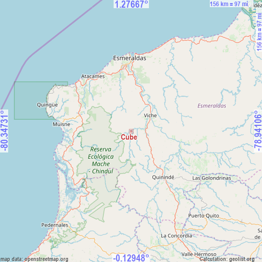
Cube GPS coordinates[2]
0° 34' 25.104" North, 79° 38' 39.048" West
| Map corner | latitude | longitude |
|---|---|---|
| Upper-left | 1.27667°, | -80.34731° |
| Center: | 0.57364°, | -79.64418° |
| Lower-right: | -0.12948°, | -78.94106° |
| Map W x H: | 156.3×156.4 km | = 97.1×97.2mi |
| max Lat: | 1.35251° ⇑6.6% North |
| Cube: | 0.57364° |
| min Lat: | ⇓93.4% South -4.38181° |
| min Long | Cube | max Long |
| -90.96654° | -79.64418° | -76.89528° |
| W 39.7%⇐ | ⇒60.3% E |
Elevation
Elevation of Cube is 138 m = 453 ft, and this is 807.1 m = 2648 ft below average elevation for this country.
| Max E: |
3131 m = 10272 ft | 52.1% |
| Avg. | 945.1 m = 3101 ft | |
| Cube | 138 m = 453 ft | |
Min E: |
1 m = 3 ft | 47.9% |
See also: Ecuador elevation on elevation.city.
Geographical zone
Cube is located in North Torrid zone (between Equator and Tropic of Cancer). Distance of Equator is 63.8 km =39.6 mi to South.| Distance of | km | miles | from Cube |
|---|---|---|---|
| North Pole | 9943.3 | 6178.5 | to North |
| Arctic Circle | 7337.4 | 4559.2 | to North |
| Tropic Cancer | 2542.1 | 1579.6 | to North |
| Equator | 63.8 | 39.6 | to South |


Nearby cities:
15 places around Cube: (largest is in red/bold)
• Bahía de Caráquez
156.5 km =97.2 mi,  213°
213°
• Chone
150 km =93.2 mi,  199°
199°
• Cotacachi
156.4 km =97.2 mi,  101°
101°
• Esmeraldas
42.9 km =26.7 mi,  358°
358°
• Muisne
41.8 km =26 mi,  275°
275°
• Pampanal de Bolívar
120.3 km =74.8 mi,  43°
43°
• Pedernales
71.9 km =44.7 mi,  219°
219°
• Quito
153.2 km =95.2 mi,  125°
125°
• Rosa Zarate
33.2 km =20.6 mi,  145°
145°
• San Lorenzo de Esmeraldas
119.9 km =74.5 mi,  48°
48°
• San Vicente
154.8 km =96.2 mi, 213°
• Santo Domingo de los Colorados
105.7 km =65.7 mi, 150°
• Tutamandahostel
153.6 km =95.4 mi,  123°
123°
• Valdez
105.1 km =65.3 mi, 44°
• Wilfrido Loor Moreira
103 km =64 mi,  180°
180°
Sources, notices
• [Note1] Compared only with cities in Ecuador existing in our database
• [Src1] Map data: © OpenStreetMap contributors (CC-BY-SA)
• [Src2] Other city data from geonames.org with taken over terms of usage.
• [Src3] Geographical zone / Annual Mean Temperature by Robert A. Rohde @ Wikipedia
