Junín geodata
Junín (Manabí) is a populated place; located in Ecuador in America/Guayaquil (GMT-5) time zone. With population of 9,128 people, there are 90 cities with bigger population in this country. Compared to other cities in Ecuador, 69.4% of cities are located further ↓South; 83.5% of cities are located further →East and 62% of cities have higher elevation than Junín. Note1


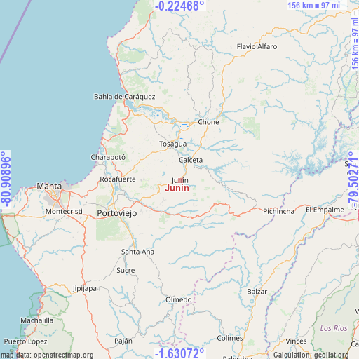
Junín GPS coordinates[2]
0° 55' 39.972" South, 80° 12' 20.988" West
| Map corner | latitude | longitude |
|---|---|---|
| Upper-left | -0.22468°, | -80.90896° |
| Center: | -0.92777°, | -80.20583° |
| Lower-right: | -1.63072°, | -79.50271° |
| Map W x H: | 156.3×156.3 km | = 97.1×97.1mi |
| max Lat: | 1.35251° ⇑30.6% North |
| Junín: | -0.92777° |
| min Lat: | ⇓69.4% South -4.38181° |
| min Long | Junín | max Long |
| -90.96654° | -80.20583° | -76.89528° |
| W 16.5%⇐ | ⇒83.5% E |
Elevation
Elevation of Junín is 49 m = 161 ft, and this is 896.1 m = 2940 ft below average elevation for this country.
| Max E: |
3131 m = 10272 ft | 62% |
| Avg. | 945.1 m = 3101 ft | |
| Junín | 49 m = 161 ft | |
Min E: |
1 m = 3 ft | 38% |
See also: Ecuador elevation on elevation.city.
Geographical zone
Junín is located in South Torrid zone (between Equator and Tropic of Capricorn). Distance of Equator is 103.2 km =64.1 mi to North.| Distance of | km | miles | from Junín |
|---|---|---|---|
| Equator | 103.2 | 64.1 | to North |
| Tropic Capricorn | 2502.8 | 1555.2 | to South |
| Antarctic Circle | 7298 | 4534.8 | to South |
| South Pole | 9903.9 | 6154 | to South |


Nearby cities:
15 places around Junín: (largest is in red/bold)
• Bahía de Caráquez
44 km =27.3 mi,  326°
326°
• Balzar
59 km =36.7 mi,  145°
145°
• Calceta
10.2 km =6.3 mi,  27°
27°
• Chone
28.4 km =17.6 mi, 26°
• Colimes
72 km =44.7 mi,  162°
162°
• Jipijapa
62.5 km =38.8 mi,  221°
221°
• Manta
56.5 km =35.1 mi,  266°
266°
• Montecristi
52 km =32.3 mi,  255°
255°
• Portoviejo
31 km =19.3 mi,  242°
242°
• Rocafuerte
27.1 km =16.8 mi, 270°
• San Vicente
43.8 km =27.2 mi, 329°
• Santa Ana
36.1 km =22.4 mi,  210°
210°
• Sucre
45.7 km =28.4 mi, 211°
• Tosagua
16 km =9.9 mi,  348°
348°
• Velasco Ibarra
64.4 km =40 mi,  101°
101°
Sources, notices
• [Note1] Compared only with cities in Ecuador existing in our database
• [Src1] Map data: © OpenStreetMap contributors (CC-BY-SA)
• [Src2] Other city data from geonames.org with taken over terms of usage.
• [Src3] Geographical zone / Annual Mean Temperature by Robert A. Rohde @ Wikipedia
