Portoviejo geodata
Portoviejo (Manabí) is a seat of a first-order administrative division; located in Ecuador in America/Guayaquil (GMT-5) time zone. With population of 170,326 people, there are 6 cities with bigger population in this country. Compared to other cities in Ecuador, 60.3% of cities are located further ↓South; 92.6% of cities are located further →East and 62.8% of cities have higher elevation than Portoviejo. Note1


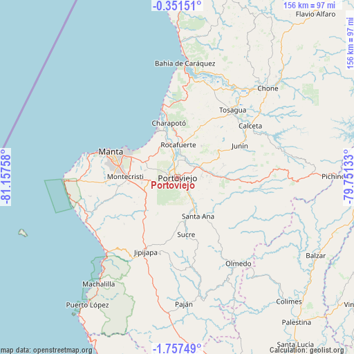
Portoviejo GPS coordinates[2]
1° 3' 16.488" South, 80° 27' 16.02" West
| Map corner | latitude | longitude |
|---|---|---|
| Upper-left | -0.35151°, | -81.15758° |
| Center: | -1.05458°, | -80.45445° |
| Lower-right: | -1.75749°, | -79.75133° |
| Map W x H: | 156.3×156.3 km | = 97.1×97.1mi |
| max Lat: | 1.35251° ⇑39.7% North |
| Portoviejo: | -1.05458° |
| min Lat: | ⇓60.3% South -4.38181° |
| min Long | Portoviejo | max Long |
| -90.96654° | -80.45445° | -76.89528° |
| W 7.4%⇐ | ⇒92.6% E |
Elevation
Elevation of Portoviejo is 44 m = 144 ft, and this is 901.1 m = 2956 ft below average elevation for this country.
| Max E: |
3131 m = 10272 ft | 62.8% |
| Avg. | 945.1 m = 3101 ft | |
| Portoviejo | 44 m = 144 ft | |
Min E: |
1 m = 3 ft | 37.2% |
See also: Portoviejo elevation on elevation.city.
Geographical zone
Portoviejo is located in South Torrid zone (between Equator and Tropic of Capricorn). Distance of Equator is 117.3 km =72.9 mi to North.| Distance of | km | miles | from Portoviejo |
|---|---|---|---|
| Equator | 117.3 | 72.9 | to North |
| Tropic Capricorn | 2488.7 | 1546.4 | to South |
| Antarctic Circle | 7283.9 | 4526 | to South |
| South Pole | 9889.8 | 6145.2 | to South |


Nearby cities:
15 places around Portoviejo: (largest is in red/bold)
• Bahía de Caráquez
50.9 km =31.6 mi,  3°
3°
• Balzar
70.2 km =43.6 mi,  119°
119°
• Calceta
39.8 km =24.7 mi,  54°
54°
• Chone
56.4 km =35 mi, 45°
• Colimes
73.5 km =45.7 mi,  137°
137°
• Jipijapa
35.5 km =22.1 mi,  202°
202°
• Junín
31 km =19.3 mi,  62°
62°
• Manta
30.5 km =19 mi,  289°
289°
• Montecristi
22.7 km =14.1 mi,  272°
272°
• Paján
55.4 km =34.4 mi,  177°
177°
• Rocafuerte
14.6 km =9.1 mi, 2°
• San Vicente
51.9 km =32.2 mi,  5°
5°
• Santa Ana
19.3 km =12 mi,  151°
151°
• Sucre
25.3 km =15.7 mi,  171°
171°
• Tosagua
38.5 km =23.9 mi,  39°
39°
Sources, notices
• [Note1] Compared only with cities in Ecuador existing in our database
• [Src1] Map data: © OpenStreetMap contributors (CC-BY-SA)
• [Src2] Other city data from geonames.org with taken over terms of usage.
• [Src3] Geographical zone / Annual Mean Temperature by Robert A. Rohde @ Wikipedia
