Valjala geodata
Valjala (Saare) is a populated place; located in Estonia in Europe/Tallinn (GMT+3) time zone. With population of 503 people, there are 177 cities with bigger population in this country. Compared to other cities in Estonia, 69.5% of cities are located further ↑North; 96.3% of cities are located further →East and 86.8% of cities have higher elevation than Valjala. Note1


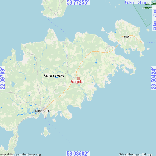
Valjala GPS coordinates[2]
58° 24' 21.996" North, 22° 48' 3.996" East
| Map corner | latitude | longitude |
|---|---|---|
| Upper-left | 58.77255°, | 22.09799° |
| Center: | 58.40611°, | 22.80111° |
| Lower-right: | 58.03582°, | 23.50424° |
| Map W x H: | 81.9×81.9 km | = 50.9×50.9mi |
| max Lat: | 59.57639° ⇑69.5% North |
| Valjala: | 58.40611° |
| min Lat: | ⇓30.5% South 57.72778° |
| min Long | Valjala | max Long |
| 22.24646° | 22.80111° | 28.19028° |
| W 3.7%⇐ | ⇒96.3% E |
Elevation
Elevation of Valjala is 15 m = 49 ft, and this is 38.2 m = 125 ft below average elevation for this country.
| Max E: |
141 m = 463 ft | 86.8% |
| Avg. | 53.2 m = 175 ft | |
| Valjala | 15 m = 49 ft | |
Min E: |
6 m = 20 ft | 13.2% |
See also: Estonia elevation on elevation.city.
Geographical zone
Valjala is located in North temperate zone (between Tropic of Cancer and the Arctic Circle). Distance of this North polar circle is 907 km =563.6 mi to North.| Distance of | km | miles | from Valjala |
|---|---|---|---|
| North Pole | 3512.9 | 2182.8 | to North |
| Arctic Circle | 907 | 563.6 | to North |
| Tropic Cancer | 3888.2 | 2416 | to South |
| Equator | 6494.2 | 4035.3 | to South |


Nearby cities:
15 places around Valjala: (largest is in red/bold)
• Aste
21.1 km =13.1 mi,  250°
250°
• Hullo
69.8 km =43.4 mi,  21°
21°
• Kuressaare
24.7 km =15.3 mi,  224°
224°
• Käina
47 km =29.2 mi,  358°
358°
• Kärdla
65.9 km =40.9 mi, 357°
• Kärla
32.5 km =20.2 mi,  256°
256°
• Lihula
67.9 km =42.2 mi,  63°
63°
• Liiva
33.8 km =21 mi,  49°
49°
• Orissaare
23.6 km =14.7 mi,  43°
43°
• Risti
62.7 km =39 mi,  74°
74°
• Ruhnu
72.3 km =44.9 mi,  158°
158°
• Salme
41.6 km =25.8 mi,  229°
229°
• Tehumardi
41 km =25.5 mi, 232°
• Tõstamaa
70.4 km =43.7 mi,  96°
96°
• Virtsu
45.8 km =28.5 mi, 66°
Sources, notices
• [Note1] Compared only with cities in Estonia existing in our database
• [Src1] Map data: © OpenStreetMap contributors (CC-BY-SA)
• [Src2] Other city data from geonames.org with taken over terms of usage.
• [Src3] Geographical zone / Annual Mean Temperature by Robert A. Rohde @ Wikipedia
