Hullo geodata
Hullo (Lääne) is a seat of a second-order administrative division; located in Estonia in Europe/Tallinn (GMT+3) time zone. With population of 104 people, there are 181 cities with bigger population in this country. Compared to other cities in Estonia, 56.8% of cities are located further ↓South; 95.3% of cities are located further →East and 96.8% of cities have higher elevation than Hullo. Note1


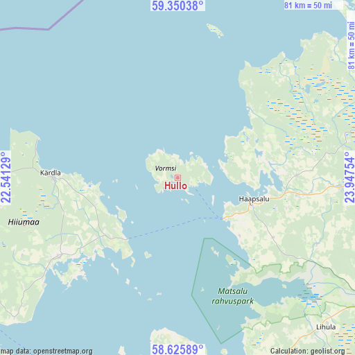
Hullo GPS coordinates[2]
58° 59' 24.144" North, 23° 14' 39.876" East
| Map corner | latitude | longitude |
|---|---|---|
| Upper-left | 59.35038°, | 22.54129° |
| Center: | 58.99004°, | 23.24441° |
| Lower-right: | 58.62589°, | 23.94754° |
| Map W x H: | 80.6×80.6 km | = 50.1×50.1mi |
| max Lat: | 59.57639° ⇑43.2% North |
| Hullo: | 58.99004° |
| min Lat: | ⇓56.8% South 57.72778° |
| min Long | Hullo | max Long |
| 22.24646° | 23.24441° | 28.19028° |
| W 4.7%⇐ | ⇒95.3% E |
Elevation
Elevation of Hullo is 9 m = 30 ft, and this is 44.2 m = 145 ft below average elevation for this country.
| Max E: |
141 m = 463 ft | 96.8% |
| Avg. | 53.2 m = 175 ft | |
| Hullo | 9 m = 30 ft | |
Min E: |
6 m = 20 ft | 3.2% |
See also: Estonia elevation on elevation.city.
Geographical zone
Hullo is located in North temperate zone (between Tropic of Cancer and the Arctic Circle). Distance of this North polar circle is 842.1 km =523.3 mi to North.| Distance of | km | miles | from Hullo |
|---|---|---|---|
| North Pole | 3448 | 2142.5 | to North |
| Arctic Circle | 842.1 | 523.3 | to North |
| Tropic Cancer | 3953.2 | 2456.4 | to South |
| Equator | 6559.1 | 4075.6 | to South |


Nearby cities:
15 places around Hullo: (largest is in red/bold)
• Haapsalu
17.8 km =11.1 mi,  107°
107°
• Käina
32.3 km =20.1 mi,  236°
236°
• Kärdla
28.4 km =17.6 mi,  271°
271°
• Lihula
48.7 km =30.3 mi,  134°
134°
• Liiva
43.2 km =26.8 mi,  179°
179°
• Orissaare
48.8 km =30.3 mi,  191°
191°
• Paldiski
61.5 km =38.2 mi,  48°
48°
• Palivere
37.8 km =23.5 mi,  93°
93°
• Riisipere
62.5 km =38.8 mi,  77°
77°
• Risti
58.8 km =36.5 mi,  144°
144°
• Taebla
29.4 km =18.3 mi,  97°
97°
• Turba
57 km =35.4 mi, 79°
• Uuemõisa
20.6 km =12.8 mi, 105°
• Vana-Vigala
64 km =39.8 mi, 112°
• Virtsu
49.4 km =30.7 mi,  160°
160°
Sources, notices
• [Note1] Compared only with cities in Estonia existing in our database
• [Src1] Map data: © OpenStreetMap contributors (CC-BY-SA)
• [Src2] Other city data from geonames.org with taken over terms of usage.
• [Src3] Geographical zone / Annual Mean Temperature by Robert A. Rohde @ Wikipedia
