Ain Sukhna geodata
Ain Sukhna (Suez) is a populated place; located in Egypt in Africa/Cairo (GMT+2) time zone. With population of 45,552 people, there are 93 cities with bigger population in this country. Compared to other cities in Egypt, 57.2% of cities are located further ↑North; 81.2% of cities are located further ←West and 68.1% of cities have lower elevation than Ain Sukhna. Note1


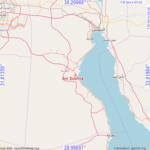
Ain Sukhna GPS coordinates[2]
29° 36' 0.648" North, 32° 19' 0.156" East
| Map corner | latitude | longitude |
|---|---|---|
| Upper-left | 30.20968°, | 31.61359° |
| Center: | 29.60018°, | 32.31671° |
| Lower-right: | 28.98697°, | 33.01984° |
| Map W x H: | 136×136 km | = 84.5×84.5mi |
| max Lat: | 31.5084° ⇑57.2% North |
| Ain Sukhna: | 29.60018° |
| min Lat: | ⇓42.8% South 22.3457° |
| min Long | Ain Sukhna | max Long |
| 25.51965° | 32.31671° | 34.89572° |
| W 81.2%⇐ | ⇒18.8% E |
Elevation
Elevation of Ain Sukhna is 30 m = 98 ft, and this is 13.5 m = 44 ft below average elevation for this country.
| Max E: |
1565 m = 5135 ft | 31.9% |
| Avg. | 43.5 m = 143 ft | |
| Ain Sukhna | 30 m = 98 ft | |
Min E: |
-15 m = -49 ft | 68.1% |
See also: Ain Sukhna elevation on elevation.city.
Geographical zone
Ain Sukhna is located in North temperate zone (between Tropic of Cancer and the Arctic Circle). Distance of this Northern Tropic circle is 685.3 km =425.8 mi to South.| Distance of | km | miles | from Ain Sukhna |
|---|---|---|---|
| North Pole | 6715.8 | 4173 | to North |
| Arctic Circle | 4109.9 | 2553.8 | to North |
| Tropic Cancer | 685.3 | 425.8 | to South |
| Equator | 3291.2 | 2045.1 | to South |


Nearby cities:
15 places around Ain Sukhna: (largest is in red/bold)
• Al Khānkah
113.9 km =70.8 mi,  306°
306°
• Al Wāsiţah
111.5 km =69.3 mi,  254°
254°
• Al Ḩawāmidīyah
108.2 km =67.2 mi,  287°
287°
• Al ‘Ayyāţ
102.4 km =63.6 mi,  271°
271°
• At Tall al Kabīr
116.7 km =72.5 mi,  333°
333°
• Aş Şaff
100.2 km =62.3 mi, 267°
• Bilbays
116.6 km =72.5 mi,  321°
321°
• Cairo
115.1 km =71.5 mi,  296°
296°
• Giza
115.9 km =72 mi, 293°
• Ismailia
111.7 km =69.4 mi,  357°
357°
• Mashtūl as Sūq
123.8 km =76.9 mi, 313°
• New Cairo
94.6 km =58.8 mi, 300°
• Shibīn al Qanāṭir
124.5 km =77.4 mi, 309°
• Suez
46.2 km =28.7 mi,  25°
25°
• Ḩalwān
101.7 km =63.2 mi, 285°
Sources, notices
• [Note1] Compared only with cities in Egypt existing in our database
• [Src1] Map data: © OpenStreetMap contributors (CC-BY-SA)
• [Src2] Other city data from geonames.org with taken over terms of usage.
• [Src3] Geographical zone / Annual Mean Temperature by Robert A. Rohde @ Wikipedia
